
 Cart
Cart
|
ITEM #OL12167
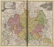
LAND GRAVIATUS HASSIAE INFERIORIS nova Tabula, in qua praecipue DITIONES HASSO-CASSELENSE ET COMITATUS WALDECK 0313-00From Grosser Atlas Published by Homann, Johann Baptist in 1716 |
 Buy this Map »
Map Information
Full Title: LAND GRAVIATUS HASSIAE INFERIORIS nova Tabula, in qua praecipue DITIONES HASSO-CASSELENSE ET COMITATUS WALDECK 0313-00
Full Atlas Title: Grosser Atlas
Location 1: Europe
Location 2: Germany
Publish Date: 1716
Publisher: Homann, Johann Baptist
Number Maps in the Atlas: 684
Map Original Width: 23.09"
Map Original Height: 20.24"
Item Number: OL12167
Collection: Osher Map Library Antique Maps Collection
Image Quality: High quality scan of original that is perfect for printed fine-art quality reproduction.
Category:
Maps and/or Atlas Quality:
TAGS:
Full Atlas Title: Grosser Atlas
Location 1: Europe
Location 2: Germany
Publish Date: 1716
Publisher: Homann, Johann Baptist
Number Maps in the Atlas: 684
Map Original Width: 23.09"
Map Original Height: 20.24"
Item Number: OL12167
Collection: Osher Map Library Antique Maps Collection
Image Quality: High quality scan of original that is perfect for printed fine-art quality reproduction.
Category:
historical maps, antique maps
Maps and/or Atlas Quality:
TAGS:
Source Institution:

Osher Map Library Smith Center For Cartographic Education
Souce Media:
Original Document
Osher Map Library Smith Center For Cartographic Education
Souce Media:
Original Document
| This antique map (LAND GRAVIATUS HASSIAE INFERIORIS n...) and atlas (Grosser Atlas) are part of the Historic Map Works, Residential Genealogy™ historical map collection, the largest digital collection of rare, ancient, old, historical, cadastral and antiquarian maps of its type. We currently have over 1,662,956 images available online. You can read about the collection or browse the entire collection. |