
 Cart
Cart
|
ITEM #OL1454
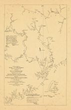
Map - Page 1 -From A Plan of the Rivers/SCOODIC AND MAGAGUADAVIC/With their principal Branches/including the/BAY OF PASSAMAQUODDY///////By George Sproute [sic] Esq'r Surveyor Gen'l/of New Brunswick////Mr. Wright Published by SPROULE, GEORGE [ERRONEOUSLY PRINTED SPROUTE ] in 1895- |
 Buy this Map »


Map Information
Full Title: Map - Page 1 - A Plan of the Rivers/SCOODIC AND MAGAGUADAVIC/With their principal Branches/including the/BAY OF PASSAMAQUODDY///////By George Sproute [sic] Esq'r Surveyor Gen'l/of New Brunswick////Mr. Wright
Full Atlas Title: A Plan of the Rivers/SCOODIC AND MAGAGUADAVIC/With their principal Branches/including the/BAY OF PASSAMAQUODDY///////By George Sproute [sic] Esq'r Surveyor Gen'l/of New Brunswick////Mr. Wright
Location 1: Unattributed
Location 2: Maine
Publish Date: 1895-
Publisher: SPROULE, GEORGE [ERRONEOUSLY PRINTED SPROUTE ]
Number Maps in the Atlas: 1
Map Original Width: 24.98"
Map Original Height: 38.68"
Item Number: OL1454
Collection: Osher Map Library Antique Maps Collection
Image Quality: High quality scan of original that is perfect for printed fine-art quality reproduction.
Category:
Maps and/or Atlas Quality:
TAGS:
Full Atlas Title: A Plan of the Rivers/SCOODIC AND MAGAGUADAVIC/With their principal Branches/including the/BAY OF PASSAMAQUODDY///////By George Sproute [sic] Esq'r Surveyor Gen'l/of New Brunswick////Mr. Wright
Location 1: Unattributed
Location 2: Maine
Publish Date: 1895-
Publisher: SPROULE, GEORGE [ERRONEOUSLY PRINTED SPROUTE ]
Number Maps in the Atlas: 1
Map Original Width: 24.98"
Map Original Height: 38.68"
Item Number: OL1454
Collection: Osher Map Library Antique Maps Collection
Image Quality: High quality scan of original that is perfect for printed fine-art quality reproduction.
Category:
historic maps, old maps
Maps and/or Atlas Quality:
TAGS:
Source Institution:

Osher Map Library Smith Center For Cartographic Education
Souce Media:
Original Document
Osher Map Library Smith Center For Cartographic Education
Souce Media:
Original Document
| This antique map (Map - Page 1) and atlas (A Plan of the Rivers/SCOODIC AND MAGAGUADAVIC/With their principal Branches/including the/BAY OF PASSAMAQUODDY///////By George Sproute [sic] Esq'r Surveyor Gen'l/of New Brunswick////Mr. Wright) are part of the Historic Map Works, Residential Genealogy™ historical map collection, the largest digital collection of rare, ancient, old, historical, cadastral and antiquarian maps of its type. We currently have over 1,662,956 images available online. You can read about the collection or browse the entire collection. |