
 Cart
Cart
|
ITEM #OL190
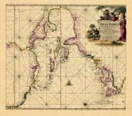
Map - Page 1 -From Pas kaart/Van/WEST INDIEN/Behelsende soo Delzelffs Vaste Kusten als d' onder/behoorenden Eylanden aan de Noord Oceaan/door Vooght Geometra. Published by KEULEN, JOHANNES VAN in 1682 |
 Buy this Map »
Map Information
Full Title: Map - Page 1 - Pas kaart/Van/WEST INDIEN/Behelsende soo Delzelffs Vaste Kusten als d' onder/behoorenden Eylanden aan de Noord Oceaan/door Vooght Geometra.
Full Atlas Title: Pas kaart/Van/WEST INDIEN/Behelsende soo Delzelffs Vaste Kusten als d' onder/behoorenden Eylanden aan de Noord Oceaan/door Vooght Geometra.
Location 1: Unattributed
Location 2: West Indies
Publish Date: 1682
Publisher: KEULEN, JOHANNES VAN
Number Maps in the Atlas: 1
Map Original Width: 24.98"
Map Original Height: 21.87"
Item Number: OL190
Collection: Osher Map Library Antique Maps Collection
Image Quality: High quality scan of original that is perfect for printed fine-art quality reproduction.
Category:
Maps and/or Atlas Quality:
TAGS:
Full Atlas Title: Pas kaart/Van/WEST INDIEN/Behelsende soo Delzelffs Vaste Kusten als d' onder/behoorenden Eylanden aan de Noord Oceaan/door Vooght Geometra.
Location 1: Unattributed
Location 2: West Indies
Publish Date: 1682
Publisher: KEULEN, JOHANNES VAN
Number Maps in the Atlas: 1
Map Original Width: 24.98"
Map Original Height: 21.87"
Item Number: OL190
Collection: Osher Map Library Antique Maps Collection
Image Quality: High quality scan of original that is perfect for printed fine-art quality reproduction.
Category:
historic maps, old maps
Maps and/or Atlas Quality:
TAGS:
Source Institution:

Osher Map Library Smith Center For Cartographic Education
Souce Media:
Original Document
Osher Map Library Smith Center For Cartographic Education
Souce Media:
Original Document
| This antique map (Map - Page 1) and atlas (Pas kaart/Van/WEST INDIEN/Behelsende soo Delzelffs Vaste Kusten als d' onder/behoorenden Eylanden aan de Noord Oceaan/door Vooght Geometra.) are part of the Historic Map Works, Residential Genealogy™ historical map collection, the largest digital collection of rare, ancient, old, historical, cadastral and antiquarian maps of its type. We currently have over 1,662,956 images available online. You can read about the collection or browse the entire collection. |