
 Cart
Cart
|
ITEM #US1602056
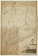
Maine State Map 1799c MHS Digital Image 5103From Maine State Map 1799c MHS Digital Image 5103, Maine Published by Osgood Carleton in 1799c |
 Buy this Map »
Full Title: Map of the District of Maine, Massachusetts : compiled from actual surveys / made by order of the General Court and under the inspection of agents of their appointment by Osgood Carleton; Maker: Osgood Carleton; Publisher: [Boston : s.n., ca. 1799?]; Date: circa 1799?; Description: Osgood Carleton, one of the first professional mapmakers in the America, made this map of Maine a few years before his A Map of Massachusetts Proper. Maine, at the time of the map's creation, was a district and part of Massachusetts. Maine become a state in 1820.; MHS Digital Image: 5103


Map Information
Full Title: Maine State Map 1799c MHS Digital Image 5103
Full Atlas Title: Maine State Map 1799c MHS Digital Image 5103
State: Maine
Location 1: North America
Location 2: United States, Maine
Publish Date: 1799c
Publisher: Osgood Carleton
Number Maps in the Atlas: 1
Map Original Width: 40.42"
Map Original Height: 58.25"
Item Number: US1602056
Collection: Historic Map Works Rare Historic Maps Collection
Image Quality: High quality scan of original that is perfect for printed fine-art quality reproduction.
Source Institution:

© The Massachusetts Historical Society, Boston, MA, USA
Souce Media:
Original Document
© The Massachusetts Historical Society, Boston, MA, USA
Souce Media:
Original Document
| This antique map (Maine State Map 1799c MHS Digital I...) and atlas (Maine State Map 1799c MHS Digital Image 5103) are part of the Historic Map Works, Residential Genealogy™ historical map collection, the largest digital collection of rare, ancient, old, historical, cadastral and antiquarian maps of its type. We currently have over 1,662,956 images available online. You can read about the collection or browse the entire collection. |