
 Cart
Cart
|
ITEM #US1602075
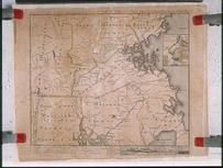
Massachusetts 1775 MHS Digital Image 0513From Massachusetts 1775 MHS Digital Image 0513, Massachusetts Published by Bernard Romans in 1775 |
 Buy this Map »
Full Title: To the Hone. Jno. Hancock, Esqre. President of ye Continental Congress, this Map of the Seat of Civil War in America, is respectfully inscribed; Maker: Bernard Romans; Publisher: [unidentified printer, 1775]; Date: 1775; Description: This map, drawn by Bernard Romans in 1775, is the first map printed in America to show Massachusetts as an independent state. The map shows rivers, creeks, hills, and towns within each existing county in Massachusetts, as well as portions of Connecticut and Rhode Island. A detail of the Boston area includes the Shawmut peninsula, Charlestown, Cambridge, and Roxbury. Across the top of the map, Romans listed the islands in Boston Harbor. Although the map is inaccurate in some local geographical details, it served its purpose of graphically conveying information concerning the scene of the fighting of various battles during the American Revolution to the rest of the colonies. The inaccuracies in the map are embodied primarily through the compression of scale of Romans? cartographic representations of Massachusetts and Rhode Island.; MHS Digital Image: 0513


Map Information
Full Title: Massachusetts 1775 MHS Digital Image 0513
Full Atlas Title: Massachusetts 1775 MHS Digital Image 0513
State: Massachusetts
Location 1: North America
Location 2: United States, Massachusetts
Publish Date: 1775
Publisher: Bernard Romans
Number Maps in the Atlas: 1
Map Original Width: 23.04"
Map Original Height: 17.46"
Item Number: US1602075
Collection: Historic Map Works Rare Historic Maps Collection
Image Quality: High quality scan of original that is perfect for printed fine-art quality reproduction.
Source Institution:

© The Massachusetts Historical Society, Boston, MA, USA
Souce Media:
Original Document
© The Massachusetts Historical Society, Boston, MA, USA
Souce Media:
Original Document
| This antique map (Massachusetts 1775 MHS Digital Imag...) and atlas (Massachusetts 1775 MHS Digital Image 0513) are part of the Historic Map Works, Residential Genealogy™ historical map collection, the largest digital collection of rare, ancient, old, historical, cadastral and antiquarian maps of its type. We currently have over 1,662,956 images available online. You can read about the collection or browse the entire collection. |