
 Cart
Cart
|
ITEM #US1602076
Massachusetts 1785c MHS Digital Image 5091From Massachusetts 1785c MHS Digital Image 5091, Massachusetts Published by Wendall family in 1785c |
 Buy this Map »
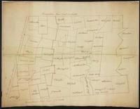
Full Title: Map of western Massachusetts, circa 1785; Maker: Wendall family; Publisher: Unattributed; Date: circa 1785; Description: This map of western Massachusetts shows cities and towns in present-day Berkshire, Franklin, Hampden, Hampshire, and Worcester counties, as well as the Connecticut River. There are large areas of Berkshire, Franklin, and Hampshire counties that are unnamed. The dotted lines roughly follow current county borderlines.; MHS Digital Image: 5091


Map Information
Full Title: Massachusetts 1785c MHS Digital Image 5091
Full Atlas Title: Massachusetts 1785c MHS Digital Image 5091
State: Massachusetts
Location 1: North America
Location 2: United States, Massachusetts
Publish Date: 1785c
Publisher: Wendall family
Number Maps in the Atlas: 1
Map Original Width: 33.05"
Map Original Height: 25.7"
Item Number: US1602076
Collection: Historic Map Works Rare Historic Maps Collection
Image Quality: High quality scan of original that is perfect for printed fine-art quality reproduction.
Source Institution:

© The Massachusetts Historical Society, Boston, MA, USA
Souce Media:
Original Document
© The Massachusetts Historical Society, Boston, MA, USA
Souce Media:
Original Document
| This antique map (Massachusetts 1785c MHS Digital Ima...) and atlas (Massachusetts 1785c MHS Digital Image 5091) are part of the Historic Map Works, Residential Genealogy™ historical map collection, the largest digital collection of rare, ancient, old, historical, cadastral and antiquarian maps of its type. We currently have over 1,662,956 images available online. You can read about the collection or browse the entire collection. |