
 Cart
Cart
|
ITEM #US1602078
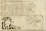
Massachusetts 1802 MHS Digital Image 2113From Massachusetts 1802 MHS Digital Image 2113, Massachusetts Published by Osgood Carleton in 1802 |
 Buy this Map »
Full Title: Map of Massachusetts proper : compiled from actual surveys made by order of the General Court and under the inspection of agents of their appointment / by Osgood Carleton.; Maker: Osgood Carleton; Publisher: Unattributed; Date: 1802; Description: This map, published in 1802, is the second edition of the first official map of Massachusetts entitied, Map of Massachusetts Proper, originally published in 1801.? The idea for a state map began to take shape in 1791 when Osgood Carleton, one of the first professional mapmakers in America, suggested a regional map of Southern New England based on town surveys. The Massachusetts Historical Society supported the idea and helped persuade the Massachusetts General Court (the state legislature) to pass a state mapping law in 1794. Osgood Carleton produced the original design of the state map using information gathered from town surveys and information supplied by the Historical Society.; MHS Digital Image: 2113


Map Information
Full Title: Massachusetts 1802 MHS Digital Image 2113
Full Atlas Title: Massachusetts 1802 MHS Digital Image 2113
State: Massachusetts
Location 1: North America
Location 2: United States, Massachusetts
Publish Date: 1802
Publisher: Osgood Carleton
Number Maps in the Atlas: 1
Map Original Width: 48.62"
Map Original Height: 32.77"
Item Number: US1602078
Collection: Historic Map Works Rare Historic Maps Collection
Image Quality: High quality scan of original that is perfect for printed fine-art quality reproduction.
Source Institution:

© The Massachusetts Historical Society, Boston, MA, USA
Souce Media:
Original Document
© The Massachusetts Historical Society, Boston, MA, USA
Souce Media:
Original Document
| This antique map (Massachusetts 1802 MHS Digital Imag...) and atlas (Massachusetts 1802 MHS Digital Image 2113) are part of the Historic Map Works, Residential Genealogy™ historical map collection, the largest digital collection of rare, ancient, old, historical, cadastral and antiquarian maps of its type. We currently have over 1,662,956 images available online. You can read about the collection or browse the entire collection. |