
 Cart
Cart
|
ITEM #US1608467
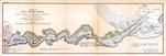
Sheet I Saco River ChartFrom Saco River 1887 From Its Mouth To Head Of Navigation, Maine Published by U. S. Engineers Office in 1887 |
 Buy this Map »


Map Information
Full Title: Sheet I Saco River Chart
Full Atlas Title: Saco River 1887 From Its Mouth To Head Of Navigation
State: Maine
Location 1: Unattributed
Location 2: Unattributed
Publish Date: 1887
Publisher: U. S. Engineers Office
Number Maps in the Atlas: 12
Map Original Width: 23.71"
Map Original Height: 8.02"
Item Number: US1608467
Collection: Historic Map Works Rare Historic Maps Collection
Image Quality: High quality scan of original that is perfect for printed fine-art quality reproduction.
Source Institution:

Souce Media:
Original Document
Souce Media:
Original Document
| This antique map (Sheet I Saco River Chart) and atlas (Saco River 1887 From Its Mouth To Head Of Navigation) are part of the Historic Map Works, Residential Genealogy™ historical map collection, the largest digital collection of rare, ancient, old, historical, cadastral and antiquarian maps of its type. We currently have over 1,662,956 images available online. You can read about the collection or browse the entire collection. |