
 Cart
Cart
|
ITEM #US1638359
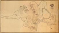
Boston 1648 Created 1919 MHS Digital Image 5104 Version 1 Digitally RestoredFrom Boston 1648 Created 1919 MHS Digital Image 5104, Massachusetts Published by Samuel Chester Clough in 1648 |
 Buy this Map »
The original of this map is held at the MHS where it was cut into six sheets for storage. These individual sheets were digitized by the MHS and later digitally assembled by HMW into a single image building upon the digital compositing work originally started by the MHS.
Notes about the two versions: Version 1 of the composited image is described as Digitally Restored due to HMW`s digital replacement of the borders which are missing on the original physical map in the MHS archive and the subsequent Version 2 composite. Though most of HMW`s fine-art reproduction customers will be interested in Version 1 for aesthetic reasons, it should be noted that Version 2 is a more faithful reproduction of the map within MHS archive (missing borders and all) and can be also ordered as a reproduction.; MHS Digital Image: 5104
Notes about the two versions: Version 1 of the composited image is described as Digitally Restored due to HMW`s digital replacement of the borders which are missing on the original physical map in the MHS archive and the subsequent Version 2 composite. Though most of HMW`s fine-art reproduction customers will be interested in Version 1 for aesthetic reasons, it should be noted that Version 2 is a more faithful reproduction of the map within MHS archive (missing borders and all) and can be also ordered as a reproduction.; MHS Digital Image: 5104
Map Information
Full Title: Boston 1648 Created 1919 MHS Digital Image 5104 Version 1 Digitally Restored
Full Atlas Title: Boston 1648 Created 1919 MHS Digital Image 5104
State: Massachusetts
Location 1: Unattributed
Location 2: Unattributed
Publish Date: 1648
Publisher: Samuel Chester Clough
Number Maps in the Atlas: 2
Map Original Width: 107.87"
Map Original Height: 61"
Item Number: US1638359
Collection: Historic Map Works Rare Historic Maps Collection
Image Quality: High quality scan of original that is perfect for printed fine-art quality reproduction.
Source Institution:

© The Massachusetts Historical Society, Boston, MA, USA
Souce Media:
Original Document
© The Massachusetts Historical Society, Boston, MA, USA
Souce Media:
Original Document
| This antique map (Boston 1648 Created 1919 MHS Digita...) and atlas (Boston 1648 Created 1919 MHS Digital Image 5104) are part of the Historic Map Works, Residential Genealogy™ historical map collection, the largest digital collection of rare, ancient, old, historical, cadastral and antiquarian maps of its type. We currently have over 1,662,956 images available online. You can read about the collection or browse the entire collection. |