
 Cart
Cart
|
ITEM #US166427
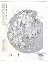
Hancock County - Section 18a - Cranberry Isles,Southwest Harbor, Arcadis Mountain, Bar Harbor, Bartlett IslandFrom Maine State Atlas 1961 to 1964 Highway Maps, Maine Published by Maine State Highway Commision in 1961 |
 Buy this Map »
Map Information
Full Title: Hancock County - Section 18a - Cranberry Isles,Southwest Harbor, Arcadis Mountain, Bar Harbor, Bartlett Island
Full Atlas Title: Maine State Atlas 1961 to 1964 Highway Maps
State: Maine
Location 1: Unattributed
Location 2: Unattributed
Publish Date: 1961
Publisher: Maine State Highway Commision
Number Maps in the Atlas: 88
Map Original Width: 18.19"
Map Original Height: 23.43"
Item Number: US166427
Collection: Historic Map Works Rare Historic Maps Collection
Image Quality: High quality scan of original that is perfect for printed fine-art quality reproduction.
Source Institution:

Souce Media:
Original Document
Souce Media:
Original Document
| This antique map (Hancock County - Section 18a - Cran...) and atlas (Maine State Atlas 1961 to 1964 Highway Maps) are part of the Historic Map Works, Residential Genealogy™ historical map collection, the largest digital collection of rare, ancient, old, historical, cadastral and antiquarian maps of its type. We currently have over 1,662,956 images available online. You can read about the collection or browse the entire collection. |