
 Cart
Cart
|
ITEM #US482340
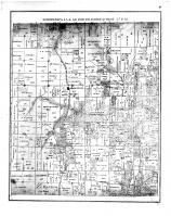
Township 45 & 46 N Range 17 W, Vermont StationFrom Cooper County 1877, Missouri Published by St. Louis Atlas Publishing Co. in 1877 |
 Buy this Map »


Map Information
Full Title: Township 45 & 46 N Range 17 W, Vermont Station
Full Atlas Title: Cooper County 1877
State: Missouri
Location 1: Unattributed
Location 2: Unattributed
Publish Date: 1877
Publisher: St. Louis Atlas Publishing Co.
Number Maps in the Atlas: 53
Map Original Width: 8.06"
Map Original Height: 10.19"
Item Number: US482340
Collection: Historic Map Works Rare Historic Maps Collection
Image Quality: Informational quality scan which is suitable for research use and lends itself nicely to being reproduced in our research print format.
Source Institution:

Souce Media:
Microfilm/Microfiche
Souce Media:
Microfilm/Microfiche
| This antique map (Township 45 & 46 N Range 17 W, Verm...) and atlas (Cooper County 1877) are part of the Historic Map Works, Residential Genealogy™ historical map collection, the largest digital collection of rare, ancient, old, historical, cadastral and antiquarian maps of its type. We currently have over 1,662,956 images available online. You can read about the collection or browse the entire collection. |