
 Cart
Cart
|
ITEM #US842187
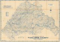
Tuolumne County 1939From Tuolumne County 1939, California Published by Metsker Maps in 1939 |
 Buy this Map »
Maps in this atlas contain names of the property owners. For the names of residents living in the dwellings in many counties, consult atlases published by either Directory Service Company or Farm and Home Publishers when available in the database. For a full list of all published atlases of this area, browse the collection by state.


Map Information
Full Title: Tuolumne County 1939
Full Atlas Title: Tuolumne County 1939
State: California
Location 1: Unattributed
Location 2: Unattributed
Publish Date: 1939
Publisher: Metsker Maps
Number Maps in the Atlas: 4
Map Original Width: 42.61"
Map Original Height: 30.08"
Item Number: US842187
Collection: Historic Map Works Rare Historic Maps Collection
Image Quality: High quality scan of original that is perfect for printed fine-art quality reproduction.
Source Institution:

Souce Media:
Original Document
Souce Media:
Original Document
| This antique map (Tuolumne County 1939) and atlas (Tuolumne County 1939) are part of the Historic Map Works, Residential Genealogy™ historical map collection, the largest digital collection of rare, ancient, old, historical, cadastral and antiquarian maps of its type. We currently have over 1,662,956 images available online. You can read about the collection or browse the entire collection. |