
 Cart
Cart
|
ITEM #US844338
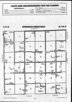
Sherman T7S-R10EFrom Pottawatomie County 1990, Kansas Published by Farm and Home Publishers, LTD in 1990 |
 Buy this Map »
These atlases contain separate maps for owners and residents. Use care to select the correct map for each township depending on the information needed.


Map Information
Full Title: Sherman T7S-R10E
Full Atlas Title: Pottawatomie County 1990
State: Kansas
Location 1: Unattributed
Location 2: Unattributed
Publish Date: 1990
Publisher: Farm and Home Publishers, LTD
Number Maps in the Atlas: 83
Map Original Width: 5.16"
Map Original Height: 7.3"
Item Number: US844338
Collection: Historic Map Works Rare Historic Maps Collection
Image Quality: High quality scan of original that is perfect for printed fine-art quality reproduction.
Source Institution:

Souce Media:
Original Document
Souce Media:
Original Document
| This antique map (Sherman T7S-R10E) and atlas (Pottawatomie County 1990) are part of the Historic Map Works, Residential Genealogy™ historical map collection, the largest digital collection of rare, ancient, old, historical, cadastral and antiquarian maps of its type. We currently have over 1,662,956 images available online. You can read about the collection or browse the entire collection. |