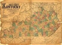
| Kentucky 1859 Eastern - APSdigobj3562 |
Kentucky |
Kentucky 1859 Eastern |
Lesley, Joseph;... |
1859 |

| Kentucky Township 1 |
Kansas |
Jefferson County 1899 |
Acme Publishing... |
1899 |

| Kentucky State Map - Right |
Kentucky |
Jefferson and Oldham Counties 1879 |
Beers & Lanagan |
1879 |

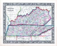
| Kentucky and Tennessee Map - Right |
Kentucky |
Bath and Fleming Counties 1884 |
D. J. Lake and ... |
1884 |
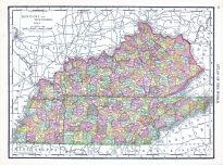
| Kentucky 1862 State Map |
Kentucky |
Kentucky 1862 State Map |
Lloyd, James T. |
1862 |

| Kentucky and Tennessee Map - Right |
Kentucky |
Henderson and Union Counties 1880 |
D. J. Lake and ... |
1880 |
| Kentucky, Tennessee |
Indiana |
Wells County 1881 |
H.H. Hardesty |
1881 |

| Kentucky Township 2, Thompsonville |
Kansas |
Jefferson County 1899 |
Acme Publishing... |
1899 |

| Kentucky State Map - Left |
Kentucky |
Jefferson and Oldham Counties 1879 |
Beers & Lanagan |
1879 |

| Kentucky T11S-R18E |
Kansas |
Jefferson County 1963 |
Directory Servi... |
1963 |

| Kentucky and Tennessee Map - Left |
Kentucky |
Bath and Fleming Counties 1884 |
D. J. Lake and ... |
1884 |

| Kentucky and Tennessee State Map - Right |
Kentucky |
Braken and Pendleton Counties 1884 |
D. J. Lake and ... |
1884 |

| Kentucky Counties Outline Map |
Kentucky |
Bourbon County 1877 |
D. G. Beers and... |
1877 |

| Kentucky Counties Outline Map |
Kentucky |
Clark County 1877 |
D. G. Beers and... |
1877 |

| Kentucky Counties Outline Map |
Kentucky |
Fayette County 1877 |
D. G. Beers and... |
1877 |

| Kentucky Counties Outline Map |
Kentucky |
Jessamine County 1877 |
D. G. Beers and... |
1877 |
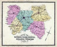
| Kentucky Counties Outline Map |
Kentucky |
Woodford County 1877 |
D. G. Beers and... |
1877 |

| Kentucky and Tennessee States Map - Right |
Kentucky |
Owen County 1883 |
D. J. Lake and ... |
1883 |

| Kentucky and Tennessee Map - Left |
Kentucky |
Henderson and Union Counties 1880 |
D. J. Lake and ... |
1880 |

| Kentucky and Tennessee States Map, Page 1 |
Kentucky |
Boone - Kenton - Campbell Counties ... |
D. J. Lake and ... |
1883 |
| Kentucky and Tennessee States Map, Page 2 |
Kentucky |
Boone - Kenton - Campbell Counties ... |
D. J. Lake and ... |
1883 |

| Kentucky and Tennessee State Map - Left |
Kentucky |
Braken and Pendleton Counties 1884 |
D. J. Lake and ... |
1884 |

| Kentucky and Tennessee State Maps - Right |
Kentucky |
Carroll and Gallatin Counties 1883 |
D. J. Lake and ... |
1883 |

| Stratton Township, Kentucky, Verilion |
Illinois |
Edgar County 1948 |
Rockford Map Pu... |
1948 |

| Kentucky and Tennessee States Map - Left |
Kentucky |
Owen County 1883 |
D. J. Lake and ... |
1883 |

| Kentucky and Tennessee State Maps - Left |
Kentucky |
Carroll and Gallatin Counties 1883 |
D. J. Lake and ... |
1883 |

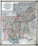
| Indiana, Illinois, Missouri, Kentucky and Tennesse... |
Ohio |
Clark County 1875 |
L. H. Everets &... |
1875 |
| Hunter, Stratton, Baldwinsville, Huffmanville, Ken... |
Illinois |
Edgar County 1870 |
Warner & Higgen... |
1870 |

| Kentucky County and Rail Road Map |
Kentucky |
Bourbon County 1877 |
D. G. Beers and... |
1877 |

| Kentucky County and Rail Road Map |
Kentucky |
Clark County 1877 |
D. G. Beers and... |
1877 |

| Kentucky County and Rail Road Map |
Kentucky |
Fayette County 1877 |
D. G. Beers and... |
1877 |

| Kentucky County and Rail Road Map |
Kentucky |
Jessamine County 1877 |
D. G. Beers and... |
1877 |

| Kentucky County and Rail Road Map |
Kentucky |
Woodford County 1877 |
D. G. Beers and... |
1877 |
| Tennessee, Kentucky, Alabama, Mississippi, Arkansa... |
Illinois |
Illinois State Atlas 1875 |
Warner and Beer... |
1875 |

| Kentucky, Brocton, Palermo, Bloomfield, Logan, Dud... |
Illinois |
Edgar County 1910 |
Geo. A. Ogle an... |
1910 |

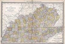
| Kentucky and Tennessee 1864 Mitchell Plate |
Kentucky |
Kentucky and Tennessee 1864 Mitchel... |
S. Augustus Mit... |
1864 |

| Kentucky and Tennessee 1864 Mitchell Plate |
Tennessee |
Kentucky and Tennessee 1864 Mitchel... |
S. Augustus Mit... |
1864 |

| Kentucky Township, Winchester, Thompsonville, Newm... |
Kansas |
Jefferson County 1916 |
Geo. A. Ogle an... |
1916 |

| County Map of Tennessee, Kentucky, Alabama, Missis... |
Illinois |
La Salle County 1876 |
Warner and Beer... |
1876 |

| County Map Tennessee, Kentucky, Alabana, Mississip... |
Missouri |
Adair County 1876 |
Harrison and Wa... |
1876 |

| County Map of Tennessee, Kentucky, Alabama, Missis... |
Illinois |
Bond County 1875 Microfilm |
Warner & Beers |
1875 |
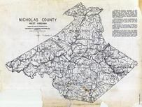
| Nicholas County - Hamilton, Jefferson, Summersvill... |
West Virginia |
West Virginia State Atlas 1933 |
Clarksburg Publ... |
1933 |
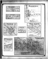
| New Athens, Logan, Bloomfield, Kentucky, Cherry Po... |
Illinois |
Edgar County 1870 |
Warner & Higgen... |
1870 |

| State Maps - County Map - Indiana, Illinois, Misso... |
Ohio |
Fayette County 1875 |
L. H. Everts |
1875 |

| Morgan - Johnson and Parts of Magoffin - Floyd - M... |
Kentucky |
Morgan - Johnson and Parts of Magof... |
Kentucky Geolog... |
188x |

 Cart
Cart