
 Cart
Cart
|
ITEM #WM2655
World Map 1790 Northern Hemisphere - APSdigobj3477From World Map 1790 Northern Hemisphere Published by in 1790 |
 Buy this Map »
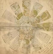
Full Title: To George Washington president of the United States of America this magnetic atlas or variation chart is humbly inscribed by John Churchman.; Creator: ; Date: 1790; Publisher: Philadelphia: James Johnson: 1790; Contributor: Unattributed; Description: Color maps showing magnetic poles of the Earth.; Notes: In: Pam. 538.7:C47e. John Churchman, An explanation of the magnetic atlas or variation chart. Philadelphia: James Johnson: 1790. Front. Churchman was an American who was devoted to his own theories of the variations of the magnetic needle and other things. He had presented his scheme to the Society in 1787 and was given mild encouragement. He founded his belief on the hypothesis of two bodies (besides the moon) revolving round the earth, in small circles parallel to the equator; one near the north pole, and the other was near the south pole; and the needle, being wholly governed by the attraction of these magnetic satellites, will, in whatever part of the world, always rest in the plane of the circle, passing through them and the given place. [The American Museum, Sept. 1789: p. 218]. He persevered in his work and at the 17 September 1790 meeting his "Navigation Chart, or Magnetick Atlas" was presented. It disappeared, but another copy was given by Johann Rodolph Valltravers on 19 May 1797. The Valltravers copy is the one now at the Society. Wheat: 6; Presented by the author to the Society, 17 September 1790, with a description. Another copy presented by Johann R. Valltravers, 19 May 1797. ; Language: English; APS Digital ID: APSdigobj3477
Map Information
Full Title: World Map 1790 Northern Hemisphere - APSdigobj3477
Full Atlas Title: World Map 1790 Northern Hemisphere
Location 1: World
Location 2: Unattributed
Publish Date: 1790
Publisher:
Number Maps in the Atlas: 1
Map Original Width: 23.73"
Map Original Height: 24.19"
Item Number: WM2655
Collection: Historic Map Works Rare Historic Maps Collection
Image Quality: High quality scan of original that is perfect for printed fine-art quality reproduction.
Source Institution:

© American Philosophical Society, Philadelphia, PA, USA
Souce Media:
Original Document
© American Philosophical Society, Philadelphia, PA, USA
Souce Media:
Original Document
| This antique map (World Map 1790 Northern Hemisphere ...) and atlas (World Map 1790 Northern Hemisphere) are part of the Historic Map Works, Residential Genealogy™ historical map collection, the largest digital collection of rare, ancient, old, historical, cadastral and antiquarian maps of its type. We currently have over 1,662,956 images available online. You can read about the collection or browse the entire collection. |