
 Cart
Cart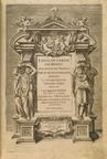
L'ISOLE PIV FAMOSE DEL MONDO DESCRITTE DA THOMASO PORCACCHI DACASTIGLIONE ...GIROLAMO PORRO PADOVANO
PORCACCHI DA CASTIGLIONE, THOMASO, 1576
Image Quality:
 High
High
An early Italian atlas describing "the most famous islands" of both the old and new worlds. Accompanying the island views are a map of North America and city maps including Venice and the newly discovered Mexico City . A detailed world map can be found towards the end of the book, followed by another world map with rhumb lines and other navigational aids.
Blank Calibration Cover, Back inside Cover, Back outside Cover, Front inside Cover, Front outside Illustration & Text Map & Text OML Barcode Other Spine Text Title Page
 Indicates a map that is georeferenced


![DESCRITTIONE DEL CONFLITTO NAVALE SVCCESSO A CVRZOLARI NEL MARE IONIO [Naval Battle at the Cvrzolari in 1571] 0124, L'ISOLE PIV FAMOSE DEL MONDO DESCRITTE DA THOMASO PORCACCHI DACASTIGLIONE ...GIROLAMO PORRO PADOVANO](/Images/Maps/OL/Bound/7340/web-7340-0124,final/TileGroup0/0-0-0.jpg "DESCRITTIONE DEL CONFLITTO NAVALE SVCCESSO A CVRZOLARI NEL MARE IONIO [Naval Battle at the Cvrzolari in 1571] 0124, L'ISOLE PIV FAMOSE DEL MONDO DESCRITTE DA THOMASO PORCACCHI DACASTIGLIONE ...GIROLAMO PORRO PADOVANO")
![DESCRITTIONE DEL MAPPAMONDO [World Map] 0230, L'ISOLE PIV FAMOSE DEL MONDO DESCRITTE DA THOMASO PORCACCHI DACASTIGLIONE ...GIROLAMO PORRO PADOVANO](/Images/Maps/OL/Bound/7340/web-7340-0230,final/TileGroup0/0-0-0.jpg "DESCRITTIONE DEL MAPPAMONDO [World Map] 0230, L'ISOLE PIV FAMOSE DEL MONDO DESCRITTE DA THOMASO PORCACCHI DACASTIGLIONE ...GIROLAMO PORRO PADOVANO")
![DESCRITTIONE DELL GRAN CITTA', E ISOLA TEMISTITAN [Mexico City] 0194, L'ISOLE PIV FAMOSE DEL MONDO DESCRITTE DA THOMASO PORCACCHI DACASTIGLIONE ...GIROLAMO PORRO PADOVANO](/Images/Maps/OL/Bound/7340/web-7340-0194,final/TileGroup0/0-0-0.jpg "DESCRITTIONE DELL GRAN CITTA', E ISOLA TEMISTITAN [Mexico City] 0194, L'ISOLE PIV FAMOSE DEL MONDO DESCRITTE DA THOMASO PORCACCHI DACASTIGLIONE ...GIROLAMO PORRO PADOVANO")
![DESCRITTIONE DELL'ARCIPELAGO [Grecian Archipelago] 0111, L'ISOLE PIV FAMOSE DEL MONDO DESCRITTE DA THOMASO PORCACCHI DACASTIGLIONE ...GIROLAMO PORRO PADOVANO](/Images/Maps/OL/Bound/7340/web-7340-0111,final/TileGroup0/0-0-0.jpg "DESCRITTIONE DELL'ARCIPELAGO [Grecian Archipelago] 0111, L'ISOLE PIV FAMOSE DEL MONDO DESCRITTE DA THOMASO PORCACCHI DACASTIGLIONE ...GIROLAMO PORRO PADOVANO")
![DESCRITTIONE DELL'ISOLA CVBA [Cuba] 0209, L'ISOLE PIV FAMOSE DEL MONDO DESCRITTE DA THOMASO PORCACCHI DACASTIGLIONE ...GIROLAMO PORRO PADOVANO](/Images/Maps/OL/Bound/7340/web-7340-0209,final/TileGroup0/0-0-0.jpg "DESCRITTIONE DELL'ISOLA CVBA [Cuba] 0209, L'ISOLE PIV FAMOSE DEL MONDO DESCRITTE DA THOMASO PORCACCHI DACASTIGLIONE ...GIROLAMO PORRO PADOVANO")
![DESCRITTIONE DELL'ISOLA D'HIBERNIA, OVERO D'IRLANDA [Ireland] 0049, L'ISOLE PIV FAMOSE DEL MONDO DESCRITTE DA THOMASO PORCACCHI DACASTIGLIONE ...GIROLAMO PORRO PADOVANO](/Images/Maps/OL/Bound/7340/web-7340-0049,final/TileGroup0/0-0-0.jpg "DESCRITTIONE DELL'ISOLA D'HIBERNIA, OVERO D'IRLANDA [Ireland] 0049, L'ISOLE PIV FAMOSE DEL MONDO DESCRITTE DA THOMASO PORCACCHI DACASTIGLIONE ...GIROLAMO PORRO PADOVANO")
![DESCRITTIONE DELL'ISOLA D'INGHILTERRA [British Isles] 0053, L'ISOLE PIV FAMOSE DEL MONDO DESCRITTE DA THOMASO PORCACCHI DACASTIGLIONE ...GIROLAMO PORRO PADOVANO](/Images/Maps/OL/Bound/7340/web-7340-0053,final/TileGroup0/0-0-0.jpg "DESCRITTIONE DELL'ISOLA D'INGHILTERRA [British Isles] 0053, L'ISOLE PIV FAMOSE DEL MONDO DESCRITTE DA THOMASO PORCACCHI DACASTIGLIONE ...GIROLAMO PORRO PADOVANO")
![DESCRITTIONE DELL'ISOLA D'ISLANDIA [Iceland] 0038, L'ISOLE PIV FAMOSE DEL MONDO DESCRITTE DA THOMASO PORCACCHI DACASTIGLIONE ...GIROLAMO PORRO PADOVANO](/Images/Maps/OL/Bound/7340/web-7340-0038,final/TileGroup0/0-0-0.jpg "DESCRITTIONE DELL'ISOLA D'ISLANDIA [Iceland] 0038, L'ISOLE PIV FAMOSE DEL MONDO DESCRITTE DA THOMASO PORCACCHI DACASTIGLIONE ...GIROLAMO PORRO PADOVANO")
![DESCRITTIONE DELL'ISOLA DEL ZANTE [Zante] 0135, L'ISOLE PIV FAMOSE DEL MONDO DESCRITTE DA THOMASO PORCACCHI DACASTIGLIONE ...GIROLAMO PORRO PADOVANO](/Images/Maps/OL/Bound/7340/web-7340-0135,final/TileGroup0/0-0-0.jpg "DESCRITTIONE DELL'ISOLA DEL ZANTE [Zante] 0135, L'ISOLE PIV FAMOSE DEL MONDO DESCRITTE DA THOMASO PORCACCHI DACASTIGLIONE ...GIROLAMO PORRO PADOVANO")
![DESCRITTIONE DELL'ISOLA DELLA CEFALONIA [Cefalonia] 0132, L'ISOLE PIV FAMOSE DEL MONDO DESCRITTE DA THOMASO PORCACCHI DACASTIGLIONE ...GIROLAMO PORRO PADOVANO](/Images/Maps/OL/Bound/7340/web-7340-0132,final/TileGroup0/0-0-0.jpg "DESCRITTIONE DELL'ISOLA DELLA CEFALONIA [Cefalonia] 0132, L'ISOLE PIV FAMOSE DEL MONDO DESCRITTE DA THOMASO PORCACCHI DACASTIGLIONE ...GIROLAMO PORRO PADOVANO")
![DESCRITTIONE DELL'ISOLA DI CANDIA [Crete] 0145, L'ISOLE PIV FAMOSE DEL MONDO DESCRITTE DA THOMASO PORCACCHI DACASTIGLIONE ...GIROLAMO PORRO PADOVANO](/Images/Maps/OL/Bound/7340/web-7340-0145,final/TileGroup0/0-0-0.jpg "DESCRITTIONE DELL'ISOLA DI CANDIA [Crete] 0145, L'ISOLE PIV FAMOSE DEL MONDO DESCRITTE DA THOMASO PORCACCHI DACASTIGLIONE ...GIROLAMO PORRO PADOVANO")
![DESCRITTIONE DELL'ISOLA DI CERIGO [Cerigo] 0143, L'ISOLE PIV FAMOSE DEL MONDO DESCRITTE DA THOMASO PORCACCHI DACASTIGLIONE ...GIROLAMO PORRO PADOVANO](/Images/Maps/OL/Bound/7340/web-7340-0143,final/TileGroup0/0-0-0.jpg "DESCRITTIONE DELL'ISOLA DI CERIGO [Cerigo] 0143, L'ISOLE PIV FAMOSE DEL MONDO DESCRITTE DA THOMASO PORCACCHI DACASTIGLIONE ...GIROLAMO PORRO PADOVANO")
![DESCRITTIONE DELL'ISOLA DI CIPRO [Cyprus] 0181, L'ISOLE PIV FAMOSE DEL MONDO DESCRITTE DA THOMASO PORCACCHI DACASTIGLIONE ...GIROLAMO PORRO PADOVANO](/Images/Maps/OL/Bound/7340/web-7340-0181,final/TileGroup0/0-0-0.jpg "DESCRITTIONE DELL'ISOLA DI CIPRO [Cyprus] 0181, L'ISOLE PIV FAMOSE DEL MONDO DESCRITTE DA THOMASO PORCACCHI DACASTIGLIONE ...GIROLAMO PORRO PADOVANO")
![DESCRITTIONE DELL'ISOLA DI CORFV [Corfu] 0119, L'ISOLE PIV FAMOSE DEL MONDO DESCRITTE DA THOMASO PORCACCHI DACASTIGLIONE ...GIROLAMO PORRO PADOVANO](/Images/Maps/OL/Bound/7340/web-7340-0119,final/TileGroup0/0-0-0.jpg "DESCRITTIONE DELL'ISOLA DI CORFV [Corfu] 0119, L'ISOLE PIV FAMOSE DEL MONDO DESCRITTE DA THOMASO PORCACCHI DACASTIGLIONE ...GIROLAMO PORRO PADOVANO")
![DESCRITTIONE DELL'ISOLA DI CORSICA [Corsica] 0078, L'ISOLE PIV FAMOSE DEL MONDO DESCRITTE DA THOMASO PORCACCHI DACASTIGLIONE ...GIROLAMO PORRO PADOVANO](/Images/Maps/OL/Bound/7340/web-7340-0078,final/TileGroup0/0-0-0.jpg "DESCRITTIONE DELL'ISOLA DI CORSICA [Corsica] 0078, L'ISOLE PIV FAMOSE DEL MONDO DESCRITTE DA THOMASO PORCACCHI DACASTIGLIONE ...GIROLAMO PORRO PADOVANO")
![DESCRITTIONE DELL'ISOLA DI ELBA [Elba] 0082, L'ISOLE PIV FAMOSE DEL MONDO DESCRITTE DA THOMASO PORCACCHI DACASTIGLIONE ...GIROLAMO PORRO PADOVANO](/Images/Maps/OL/Bound/7340/web-7340-0082,final/TileGroup0/0-0-0.jpg "DESCRITTIONE DELL'ISOLA DI ELBA [Elba] 0082, L'ISOLE PIV FAMOSE DEL MONDO DESCRITTE DA THOMASO PORCACCHI DACASTIGLIONE ...GIROLAMO PORRO PADOVANO")
![DESCRITTIONE DELL'ISOLA DI GOTLANDIA [Gotland] 0046, L'ISOLE PIV FAMOSE DEL MONDO DESCRITTE DA THOMASO PORCACCHI DACASTIGLIONE ...GIROLAMO PORRO PADOVANO](/Images/Maps/OL/Bound/7340/web-7340-0046,final/TileGroup0/0-0-0.jpg "DESCRITTIONE DELL'ISOLA DI GOTLANDIA [Gotland] 0046, L'ISOLE PIV FAMOSE DEL MONDO DESCRITTE DA THOMASO PORCACCHI DACASTIGLIONE ...GIROLAMO PORRO PADOVANO")
![DESCRITTIONE DELL'ISOLA DI HOLLANDA [Holland] 0064, L'ISOLE PIV FAMOSE DEL MONDO DESCRITTE DA THOMASO PORCACCHI DACASTIGLIONE ...GIROLAMO PORRO PADOVANO](/Images/Maps/OL/Bound/7340/web-7340-0064,final/TileGroup0/0-0-0.jpg "DESCRITTIONE DELL'ISOLA DI HOLLANDA [Holland] 0064, L'ISOLE PIV FAMOSE DEL MONDO DESCRITTE DA THOMASO PORCACCHI DACASTIGLIONE ...GIROLAMO PORRO PADOVANO")

![DESCRITTIONE DELL'ISOLA DI MAIORICA [Majorca] 0073, L'ISOLE PIV FAMOSE DEL MONDO DESCRITTE DA THOMASO PORCACCHI DACASTIGLIONE ...GIROLAMO PORRO PADOVANO](/Images/Maps/OL/Bound/7340/web-7340-0073,final/TileGroup0/0-0-0.jpg "DESCRITTIONE DELL'ISOLA DI MAIORICA [Majorca] 0073, L'ISOLE PIV FAMOSE DEL MONDO DESCRITTE DA THOMASO PORCACCHI DACASTIGLIONE ...GIROLAMO PORRO PADOVANO")
![DESCRITTIONE DELL'ISOLA DI MALTA [Malta] 0095, L'ISOLE PIV FAMOSE DEL MONDO DESCRITTE DA THOMASO PORCACCHI DACASTIGLIONE ...GIROLAMO PORRO PADOVANO](/Images/Maps/OL/Bound/7340/web-7340-0095,final/TileGroup0/0-0-0.jpg "DESCRITTIONE DELL'ISOLA DI MALTA [Malta] 0095, L'ISOLE PIV FAMOSE DEL MONDO DESCRITTE DA THOMASO PORCACCHI DACASTIGLIONE ...GIROLAMO PORRO PADOVANO")
![DESCRITTIONE DELL'ISOLA DI METELLINO [Lesbos] 0165, L'ISOLE PIV FAMOSE DEL MONDO DESCRITTE DA THOMASO PORCACCHI DACASTIGLIONE ...GIROLAMO PORRO PADOVANO](/Images/Maps/OL/Bound/7340/web-7340-0165,final/TileGroup0/0-0-0.jpg "DESCRITTIONE DELL'ISOLA DI METELLINO [Lesbos] 0165, L'ISOLE PIV FAMOSE DEL MONDO DESCRITTE DA THOMASO PORCACCHI DACASTIGLIONE ...GIROLAMO PORRO PADOVANO")
![DESCRITTIONE DELL'ISOLA DI MILO [Milos] 0158, L'ISOLE PIV FAMOSE DEL MONDO DESCRITTE DA THOMASO PORCACCHI DACASTIGLIONE ...GIROLAMO PORRO PADOVANO](/Images/Maps/OL/Bound/7340/web-7340-0158,final/TileGroup0/0-0-0.jpg "DESCRITTIONE DELL'ISOLA DI MILO [Milos] 0158, L'ISOLE PIV FAMOSE DEL MONDO DESCRITTE DA THOMASO PORCACCHI DACASTIGLIONE ...GIROLAMO PORRO PADOVANO")
![DESCRITTIONE DELL'ISOLA DI MINORICA [Minorca] 0076, L'ISOLE PIV FAMOSE DEL MONDO DESCRITTE DA THOMASO PORCACCHI DACASTIGLIONE ...GIROLAMO PORRO PADOVANO](/Images/Maps/OL/Bound/7340/web-7340-0076,final/TileGroup0/0-0-0.jpg "DESCRITTIONE DELL'ISOLA DI MINORICA [Minorca] 0076, L'ISOLE PIV FAMOSE DEL MONDO DESCRITTE DA THOMASO PORCACCHI DACASTIGLIONE ...GIROLAMO PORRO PADOVANO")

![DESCRITTIONE DELL'ISOLA DI NICSIA [Nicosi] 0160, L'ISOLE PIV FAMOSE DEL MONDO DESCRITTE DA THOMASO PORCACCHI DACASTIGLIONE ...GIROLAMO PORRO PADOVANO](/Images/Maps/OL/Bound/7340/web-7340-0160,final/TileGroup0/0-0-0.jpg "DESCRITTIONE DELL'ISOLA DI NICSIA [Nicosi] 0160, L'ISOLE PIV FAMOSE DEL MONDO DESCRITTE DA THOMASO PORCACCHI DACASTIGLIONE ...GIROLAMO PORRO PADOVANO")

![DESCRITTIONE DELL'ISOLA DI S. GIOVANNI detta Borichen [Puerto Rico] 0219, L'ISOLE PIV FAMOSE DEL MONDO DESCRITTE DA THOMASO PORCACCHI DACASTIGLIONE ...GIROLAMO PORRO PADOVANO](/Images/Maps/OL/Bound/7340/web-7340-0219,final/TileGroup0/0-0-0.jpg "DESCRITTIONE DELL'ISOLA DI S. GIOVANNI detta Borichen [Puerto Rico] 0219, L'ISOLE PIV FAMOSE DEL MONDO DESCRITTE DA THOMASO PORCACCHI DACASTIGLIONE ...GIROLAMO PORRO PADOVANO")
![DESCRITTIONE DELL'ISOLA DI S. LORENZO [Madagascar] 0215, L'ISOLE PIV FAMOSE DEL MONDO DESCRITTE DA THOMASO PORCACCHI DACASTIGLIONE ...GIROLAMO PORRO PADOVANO](/Images/Maps/OL/Bound/7340/web-7340-0215,final/TileGroup0/0-0-0.jpg "DESCRITTIONE DELL'ISOLA DI S. LORENZO [Madagascar] 0215, L'ISOLE PIV FAMOSE DEL MONDO DESCRITTE DA THOMASO PORCACCHI DACASTIGLIONE ...GIROLAMO PORRO PADOVANO")
![DESCRITTIONE DELL'ISOLA DI SARDIGNA [Sardinia] 0084, L'ISOLE PIV FAMOSE DEL MONDO DESCRITTE DA THOMASO PORCACCHI DACASTIGLIONE ...GIROLAMO PORRO PADOVANO](/Images/Maps/OL/Bound/7340/web-7340-0084,final/TileGroup0/0-0-0.jpg "DESCRITTIONE DELL'ISOLA DI SARDIGNA [Sardinia] 0084, L'ISOLE PIV FAMOSE DEL MONDO DESCRITTE DA THOMASO PORCACCHI DACASTIGLIONE ...GIROLAMO PORRO PADOVANO")
![DESCRITTIONE DELL'ISOLA DI SATORINI [Santorini] 0156, L'ISOLE PIV FAMOSE DEL MONDO DESCRITTE DA THOMASO PORCACCHI DACASTIGLIONE ...GIROLAMO PORRO PADOVANO](/Images/Maps/OL/Bound/7340/web-7340-0156,final/TileGroup0/0-0-0.jpg "DESCRITTIONE DELL'ISOLA DI SATORINI [Santorini] 0156, L'ISOLE PIV FAMOSE DEL MONDO DESCRITTE DA THOMASO PORCACCHI DACASTIGLIONE ...GIROLAMO PORRO PADOVANO")
![DESCRITTIONE DELL'ISOLA DI SCARPANTO [Scarpanto] 0150, L'ISOLE PIV FAMOSE DEL MONDO DESCRITTE DA THOMASO PORCACCHI DACASTIGLIONE ...GIROLAMO PORRO PADOVANO](/Images/Maps/OL/Bound/7340/web-7340-0150,final/TileGroup0/0-0-0.jpg "DESCRITTIONE DELL'ISOLA DI SCARPANTO [Scarpanto] 0150, L'ISOLE PIV FAMOSE DEL MONDO DESCRITTE DA THOMASO PORCACCHI DACASTIGLIONE ...GIROLAMO PORRO PADOVANO")
![DESCRITTIONE DELL'ISOLA DI SCIO [Chios] 0162, L'ISOLE PIV FAMOSE DEL MONDO DESCRITTE DA THOMASO PORCACCHI DACASTIGLIONE ...GIROLAMO PORRO PADOVANO](/Images/Maps/OL/Bound/7340/web-7340-0162,final/TileGroup0/0-0-0.jpg "DESCRITTIONE DELL'ISOLA DI SCIO [Chios] 0162, L'ISOLE PIV FAMOSE DEL MONDO DESCRITTE DA THOMASO PORCACCHI DACASTIGLIONE ...GIROLAMO PORRO PADOVANO")
![DESCRITTIONE DELL'ISOLA DI SICILIA [Sicily] 0088, L'ISOLE PIV FAMOSE DEL MONDO DESCRITTE DA THOMASO PORCACCHI DACASTIGLIONE ...GIROLAMO PORRO PADOVANO](/Images/Maps/OL/Bound/7340/web-7340-0088,final/TileGroup0/0-0-0.jpg "DESCRITTIONE DELL'ISOLA DI SICILIA [Sicily] 0088, L'ISOLE PIV FAMOSE DEL MONDO DESCRITTE DA THOMASO PORCACCHI DACASTIGLIONE ...GIROLAMO PORRO PADOVANO")
![DESCRITTIONE DELL'ISOLA DI TAPROBANA [Unknown or phantom island in the Indian Ocean] 0222, L'ISOLE PIV FAMOSE DEL MONDO DESCRITTE DA THOMASO PORCACCHI DACASTIGLIONE ...GIROLAMO PORRO PADOVANO](/Images/Maps/OL/Bound/7340/web-7340-0222,final/TileGroup0/0-0-0.jpg "DESCRITTIONE DELL'ISOLA DI TAPROBANA [Unknown or phantom island in the Indian Ocean] 0222, L'ISOLE PIV FAMOSE DEL MONDO DESCRITTE DA THOMASO PORCACCHI DACASTIGLIONE ...GIROLAMO PORRO PADOVANO")
![DESCRITTIONE DELL'ISOLA DISCOTIA [Scotland] 0060, L'ISOLE PIV FAMOSE DEL MONDO DESCRITTE DA THOMASO PORCACCHI DACASTIGLIONE ...GIROLAMO PORRO PADOVANO](/Images/Maps/OL/Bound/7340/web-7340-0060,final/TileGroup0/0-0-0.jpg "DESCRITTIONE DELL'ISOLA DISCOTIA [Scotland] 0060, L'ISOLE PIV FAMOSE DEL MONDO DESCRITTE DA THOMASO PORCACCHI DACASTIGLIONE ...GIROLAMO PORRO PADOVANO")
![DESCRITTIONE DELL'ISOLA ET TERRA DI SANTA CROCE, OVERO MONDO NUOUO [New World] 0198, L'ISOLE PIV FAMOSE DEL MONDO DESCRITTE DA THOMASO PORCACCHI DACASTIGLIONE ...GIROLAMO PORRO PADOVANO](/Images/Maps/OL/Bound/7340/web-7340-0198,final/TileGroup0/0-0-0.jpg "DESCRITTIONE DELL'ISOLA ET TERRA DI SANTA CROCE, OVERO MONDO NUOUO [New World] 0198, L'ISOLE PIV FAMOSE DEL MONDO DESCRITTE DA THOMASO PORCACCHI DACASTIGLIONE ...GIROLAMO PORRO PADOVANO")
![DESCRITTIONE DELL'ISOLA IAMAICA HORA DETTA DE S. IACOPO [Jamaica] 0212, L'ISOLE PIV FAMOSE DEL MONDO DESCRITTE DA THOMASO PORCACCHI DACASTIGLIONE ...GIROLAMO PORRO PADOVANO](/Images/Maps/OL/Bound/7340/web-7340-0212,final/TileGroup0/0-0-0.jpg "DESCRITTIONE DELL'ISOLA IAMAICA HORA DETTA DE S. IACOPO [Jamaica] 0212, L'ISOLE PIV FAMOSE DEL MONDO DESCRITTE DA THOMASO PORCACCHI DACASTIGLIONE ...GIROLAMO PORRO PADOVANO")

![DESCRITTIONE DELL'ISOLA SELANDIE [Zeeland and Netherlands] 0069, L'ISOLE PIV FAMOSE DEL MONDO DESCRITTE DA THOMASO PORCACCHI DACASTIGLIONE ...GIROLAMO PORRO PADOVANO](/Images/Maps/OL/Bound/7340/web-7340-0069,final/TileGroup0/0-0-0.jpg "DESCRITTIONE DELL'ISOLA SELANDIE [Zeeland and Netherlands] 0069, L'ISOLE PIV FAMOSE DEL MONDO DESCRITTE DA THOMASO PORCACCHI DACASTIGLIONE ...GIROLAMO PORRO PADOVANO")
![DESCRITTIONE DELL'ISOLA SPAGNVOLA [Hispaniola] 0202, L'ISOLE PIV FAMOSE DEL MONDO DESCRITTE DA THOMASO PORCACCHI DACASTIGLIONE ...GIROLAMO PORRO PADOVANO](/Images/Maps/OL/Bound/7340/web-7340-0202,final/TileGroup0/0-0-0.jpg "DESCRITTIONE DELL'ISOLA SPAGNVOLA [Hispaniola] 0202, L'ISOLE PIV FAMOSE DEL MONDO DESCRITTE DA THOMASO PORCACCHI DACASTIGLIONE ...GIROLAMO PORRO PADOVANO")
![DESCRITTIONE DELL'ISOLE HEBRIDI ET ORCADI [Hebrides and Orkney Islands] 0041, L'ISOLE PIV FAMOSE DEL MONDO DESCRITTE DA THOMASO PORCACCHI DACASTIGLIONE ...GIROLAMO PORRO PADOVANO](/Images/Maps/OL/Bound/7340/web-7340-0041,final/TileGroup0/0-0-0.jpg "DESCRITTIONE DELL'ISOLE HEBRIDI ET ORCADI [Hebrides and Orkney Islands] 0041, L'ISOLE PIV FAMOSE DEL MONDO DESCRITTE DA THOMASO PORCACCHI DACASTIGLIONE ...GIROLAMO PORRO PADOVANO")
![DESCRITTIONE DELL'ISOLE MOLVCCHE [Maluku Islands or Spice Islands] 0226, L'ISOLE PIV FAMOSE DEL MONDO DESCRITTE DA THOMASO PORCACCHI DACASTIGLIONE ...GIROLAMO PORRO PADOVANO](/Images/Maps/OL/Bound/7340/web-7340-0226,final/TileGroup0/0-0-0.jpg "DESCRITTIONE DELL'ISOLE MOLVCCHE [Maluku Islands or Spice Islands] 0226, L'ISOLE PIV FAMOSE DEL MONDO DESCRITTE DA THOMASO PORCACCHI DACASTIGLIONE ...GIROLAMO PORRO PADOVANO")
![DESCRITTIONE DELLA CITTA DI VINETIA [Venice] 0102, L'ISOLE PIV FAMOSE DEL MONDO DESCRITTE DA THOMASO PORCACCHI DACASTIGLIONE ...GIROLAMO PORRO PADOVANO](/Images/Maps/OL/Bound/7340/web-7340-0102,final/TileGroup0/0-0-0.jpg "DESCRITTIONE DELLA CITTA DI VINETIA [Venice] 0102, L'ISOLE PIV FAMOSE DEL MONDO DESCRITTE DA THOMASO PORCACCHI DACASTIGLIONE ...GIROLAMO PORRO PADOVANO")
![DESCRITTIONE DELLA MOREA, MOREA PENISOLA [Morean Peninsula] 0138, L'ISOLE PIV FAMOSE DEL MONDO DESCRITTE DA THOMASO PORCACCHI DACASTIGLIONE ...GIROLAMO PORRO PADOVANO](/Images/Maps/OL/Bound/7340/web-7340-0138,final/TileGroup0/0-0-0.jpg "DESCRITTIONE DELLA MOREA, MOREA PENISOLA [Morean Peninsula] 0138, L'ISOLE PIV FAMOSE DEL MONDO DESCRITTE DA THOMASO PORCACCHI DACASTIGLIONE ...GIROLAMO PORRO PADOVANO")
![DESCRITTIONE DI COSTANTINOPLI [Constantinople - Istanbul] 0168, L'ISOLE PIV FAMOSE DEL MONDO DESCRITTE DA THOMASO PORCACCHI DACASTIGLIONE ...GIROLAMO PORRO PADOVANO](/Images/Maps/OL/Bound/7340/web-7340-0168,final/TileGroup0/0-0-0.jpg "DESCRITTIONE DI COSTANTINOPLI [Constantinople - Istanbul] 0168, L'ISOLE PIV FAMOSE DEL MONDO DESCRITTE DA THOMASO PORCACCHI DACASTIGLIONE ...GIROLAMO PORRO PADOVANO")
![DISCORSO INTORNO ALLA CARTA DA NAVIGARE [MAP TO SAIL AROUND THE WORLD] 0235, L'ISOLE PIV FAMOSE DEL MONDO DESCRITTE DA THOMASO PORCACCHI DACASTIGLIONE ...GIROLAMO PORRO PADOVANO](/Images/Maps/OL/Bound/7340/web-7340-0235,final/TileGroup0/0-0-0.jpg "DISCORSO INTORNO ALLA CARTA DA NAVIGARE [MAP TO SAIL AROUND THE WORLD] 0235, L'ISOLE PIV FAMOSE DEL MONDO DESCRITTE DA THOMASO PORCACCHI DACASTIGLIONE ...GIROLAMO PORRO PADOVANO")


These antique maps and atlases are part of the Historic Map Works, Residential Genealogy™ historical map collection, the largest digital collection of rare, ancient, old, historical, cadastral and antiquarian maps of its type. Read about the collection. Browse entire collection.
Research Prints
All research prints will be printed with a light watermark.
Research Prints are color prints fitted to 11" x 17" paper ideal for research and educational use, but not suitable for framing as center seams and imperfections will not be removed. Orders for less than 15 research prints will be mailed folded in an envelope. Larger orders will be shipped flat via UPS.
All research prints will be printed with a light watermark.
Click here to see an example of a research print.
Research Prints are color prints fitted to 11" x 17" paper ideal for research and educational use, but not suitable for framing as center seams and imperfections will not be removed. Orders for less than 15 research prints will be mailed folded in an envelope. Larger orders will be shipped flat via UPS.