Delaware Historical Maps and Atlases
The state of Delaware collection contains 5 atlases spanning 269 years of growth and development (1681 through 1950).
Within the atlases are 52 historical maps, illustrations, and histories many of which contain family names ideal for genealogical research. Others are rare antique maps, part of the collection by an exclusive arrangement with the Osher Map Library. The state of Delaware has 8 of these antiquarian maps dating back as early as 1681.
|
Displaying 1- 5 of 5 in total
|
|
Click on a column header to sort table.
|
Name |
Attributes |
Quality |
Publisher |
State |
Date |
|
Name |
Atlas |
Attributes |
Publisher |
Date |
Collection |
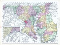 |
Maryland and Delaware |
World Atlas 1913 |
 |
Rand McNally and Com... |
1913 |
HMW |
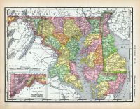 |
Page 069 - Maryland and Delawa... |
World Atlas 1911c from Minneso... |
|
Rand, McNally and Co... |
1911 |
HMW |
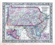 |
Pennsylvania, New Jersey, Mary... |
World Atlas 1864 Mitchells New... |
|
S. Augustus Mitchell |
1864 |
HMW |
 |
Map - Page 1 |
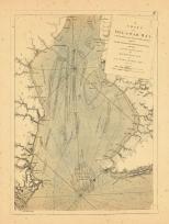
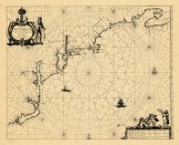
A Chart of Delaware Bay, With ... |
|
Des Barres, Joseph F... |
1779 |
OML |
|
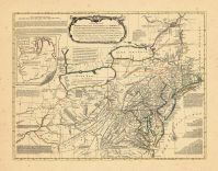 |
Map - Page 1 - A General/MAP o... |
A General/MAP of the/MIDDLE BR... |
|
EVANS, LEWIS / BOWLE... |
1765- |
OML |
|
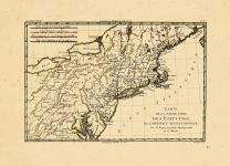 |
Map - Page 1 - CARTE/DE LA PAR... |
CARTE/DE LA PARTIE NORD,/DES E... |
|
BONNE, RIGOBERT |
1780 |
OML |
|
 |
Map - Page 1 - Pascaerte van/N... |
Pascaerte van/NIEV NEDERLANT,/... |
|
JACOBSZ, THEUNIS [LO... |
1681 |
OML |
|
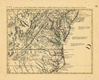 |
Map - Page 9 - LE COLONIE UNIT... |
LE COLONIE UNITE DELL AMERICA ... |
|
MITCHELL, JOHN / ZAT... |
1778 |
OML |
|
|
Displaying 1- 5 of 5 in total
|
|

 Cart
Cart