 |
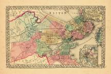
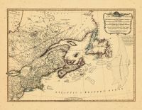
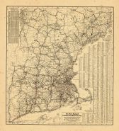
Boston, Charlestown, East Camb... |
World Atlas 1864 Mitchells New... |
 |
S. Augustus Mitchell |
1864 |
HMW |
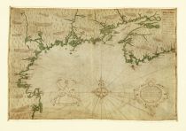 |
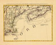
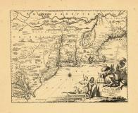
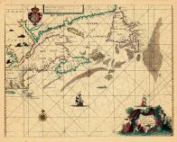
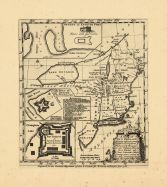
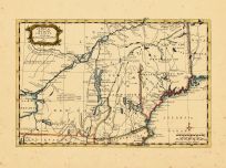
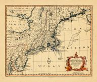
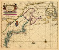
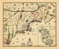
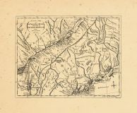
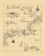
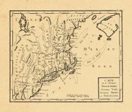
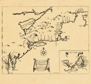
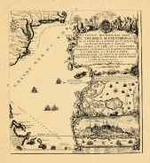
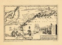
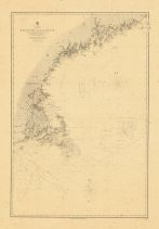
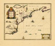
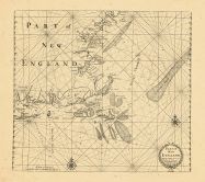
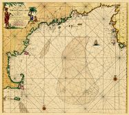
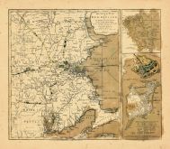
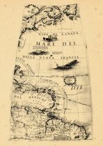
Cape Cod to Nova Scotia 1607 S... |
Cape Cod to Nova Scotia 1607 S... |
|
Samuel de Champlain |
1607 |
HMW |
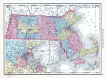 |
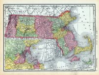
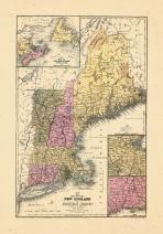
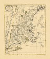
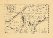
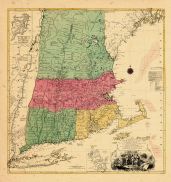
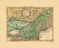
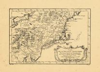
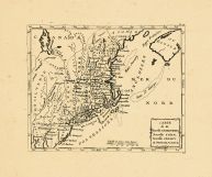
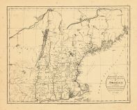
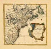
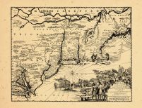
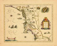
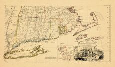
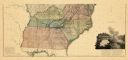
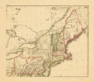
Massachusetts |
World Atlas 1913 |
|
Rand McNally and Com... |
1913 |
HMW |
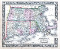 |
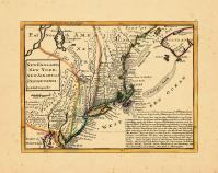
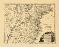
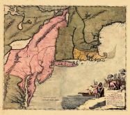
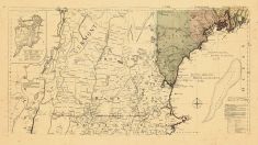
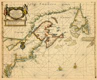
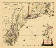
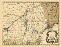
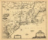
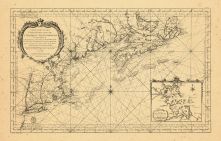
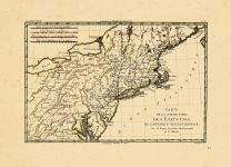
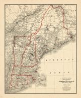
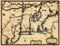
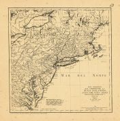
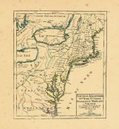
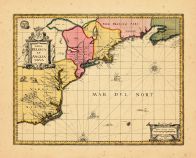
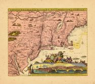
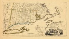
Massachusetts, Connecticut and... |
World Atlas 1864 Mitchells New... |
|
S. Augustus Mitchell |
1864 |
HMW |
 |
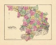
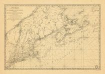
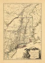
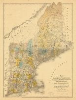
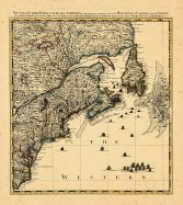
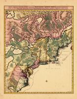
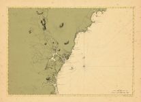
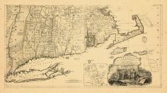
Page 063 - Massachusetts |
World Atlas 1911c from Minneso... |
|
Rand, McNally and Co... |
1911 |
HMW |
 |
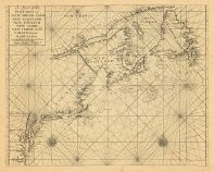
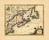
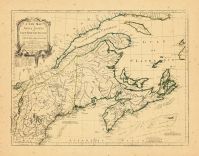
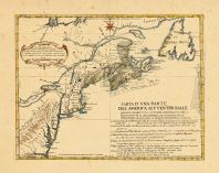
Map - Page 1 |
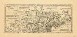
L'ACADIA,LE PROVINCIE DI SAGAD... |
|
MITCHELL, JOHN / ZAT... |
1778 |
OML |
|
 |
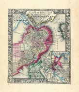
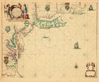
Map - Page 1 |
Plan of Boston |
|
S. Augustus Mitchell... |
1870 |
OML |
|
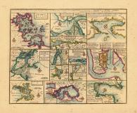 |
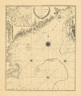
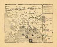
Map - Page 1 |
Particular Droughts and Plans ... |
|
Bowen, Emanuel |
1747 |
OML |
|
 |
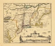
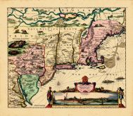
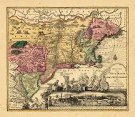
Map - Page 1 |
Nova Belgii Quod Nunc Novi Jor... |
|
[Ogilby, John] |
1671 |
OML |
|
 |
Map - Page 1 |
New England, New York, New Jer... |
|
Moll, Herman |
1729 |
OML |
|
 |
Map - Page 1 |
Map of New England or Eastern ... |
|
S. Augustus Mitchell |
1844 |
OML |
|
 |
Map - Page 1 |
Map of Middlesex County, Mass. |
|
Geo. H. Walker & Co. |
1889 |
OML |
|
 |
Map - Page 1 |
Tierra Nueva |
|
Ruscelli, Girolaneo |
1562 |
OML |
|
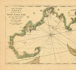 |
Map - Page 1 |
A New and Correct Chart of the... |
|
Barnsely, Henry |
1763 |
OML |
|
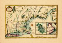 |
Map - Page 1 |
A New Map fo New England |
|
Neal, Daniel |
1720 |
OML |
|
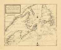 |
Map - Page 1 - A Chart of the ... |
A Chart of the Coast of/NEW FO... |
|
SELLER, JEREMIAH AND... |
1703 |
OML |
|
 |
Map - Page 1 - A Chart of the/... |
A Chart of the/Coast of/AMERIC... |
|
SELLER, JOHN |
1675 |
OML |
|
 |
Map - Page 1 - A Chart of the/... |
A Chart of the/Sea Coast of/NE... |
|
THORNTON, JOHN / MOU... |
1713 |
OML |
|
 |
Map - Page 1 - A Chart/of the ... |
A Chart/of the Sea coasts of/N... |
|
SELLER, JOHN |
1675- |
OML |
|
 |
Map - Page 1 - A CHART/OF THE/... |
A CHART/OF THE/COAST OF NEW EN... |
|
HOLLAND, SAMUEL / NO... |
1798 |
OML |
|
 |
Map - Page 1 - A Map of the BR... |
A Map of the BRITISH and FRENC... |
|
BOWEN, THOMAS |
1764 |
OML |
|
 |
Map - Page 1 - A Map of the mo... |
A Map of the most INHABITED pa... |
|
BOWLES, JOHN/ BOWLES... |
1765- |
OML |
|
 |
Map - Page 1 - A MAP of the/BR... |
A MAP of the/BRITISH/AMERICAN ... |
|
BOWEN, EMANUEL |
1754 |
OML |
|
 |
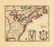
Map - Page 1 - A MAP OF/NEW EN... |
A MAP OF/NEW ENGLAND,/Being th... |
|
FOSTER, JOHN |
1677 |
OML |
|
 |
Map - Page 1 - A Map of/NEW EN... |
A Map of/NEW ENGLAND/and ye Co... |
|
GENERAL MAGAZINE OF ... |
1755 |
OML |
|
 |
Map - Page 1 - A Map of/New EN... |
A Map of/New ENGLAND/New YORKE... |
|
MORDEN, ROBERT and B... |
1676 |
OML |
|
 |
Map - Page 1 - A MAP OF/that p... |
A MAP OF/that part of/AMERICA/... |
|
GENTLEMAN'S MAGAZINE |
1757 |
OML |
|
 |
Map - Page 1 - A MAP OF/that p... |
A MAP OF/that part of/AMERICA/... |
|
GENTLEMAN'S MAGAZINE |
1757 |
OML |
|
 |
Map - Page 1 - A MAP OF/that p... |
A MAP OF/that part of/AMERICA/... |
|
GENTLEMAN'S MAGAZINE |
1757 |
OML |
|
 |
Map - Page 1 - A MAP of/the mo... |
A MAP of/the most INHABITED pa... |
|
JEFFERYS, T. / LOTTE... |
1776 |
OML |
|
 |
Map - Page 1 - A MAP of/the mo... |
A MAP of/the most INHABITED pa... |
|
JEFFERYS, THOMAS / G... |
1794 |
OML |
|
 |
Map - Page 1 - A MAP/of the/BR... |
A MAP/of the/BRITISH and FRENC... |
|
LONDON MAGAZINE |
1755 |
OML |
|
 |
Map - Page 1 - A NEW AND CORRE... |
A NEW AND CORRECT MAP/OF THE/B... |
|
LAURIE and WHITTLE |
1794 |
OML |
|
 |
Map - Page 1 - A New and/ACCUR... |
A New and/ACCURATE MAP OF/NEW ... |
|
BOWEN, EMANUEL |
1752 |
OML |
|
 |
Map - Page 1 - A NEW and/ACCUR... |
A NEW and/ACCURATE MAP/of the ... |
|
ROYAL MAGAZINE / ROL... |
1759 |
OML |
|
 |
Map - Page 1 - A New Chart for... |
A New Chart for the/Seacoasts ... |
|
THORNTON, JOHN/FISHE... |
1687 |
OML |
|
 |
Map - Page 1 - A New Chart of ... |
A New Chart of the Sea Coast o... |
|
THORNTON, JOHN |
1685- |
OML |
|
 |
Map - Page 1 - A NEW MAP OF NE... |
A NEW MAP OF NEW ENGLAND-NEW Y... |
|
THORNTON, JOHN /ROBE... |
1690- |
OML |
|
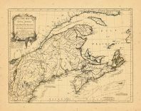 |
Map - Page 1 - A NEW MAP OF NO... |
A NEW MAP OF NOVA SCOTIA,and C... |
|
JEFFERYS, THOMAS |
1775 |
OML |
|
 |
Map - Page 1 - A New MAP of/th... |
A New MAP of/the/BRITISH DOMIN... |
|
ANNUAL REGISTER / KI... |
1763 |
OML |
|
 |
Map - Page 1 - A NEW MAP/of/NO... |
A NEW MAP/of/NOVA SCOTIA/and/C... |
|
JEFFERYS, THOMAS |
1775 |
OML |
|
 |
Map - Page 1 - A NEW MAPP OF/N... |
A NEW MAPP OF/NEW ENGLAND/and/... |
|
BROWNE, C[HRISTOPHER... |
1714 |
OML |
|
 |
Map - Page 1 - A PLAN of the T... |
A PLAN of the TOWN/AND/CHART o... |
|
GENTLEMAN'S MAGAZINE |
1775 |
OML |
|
 |
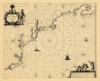
Map - Page 1 - A/Correct Map o... |
A/Correct Map of the Coast/OF/... |
|
SOUTHACK, CYPRIAN |
1731 |
OML |
|
 |
Map - Page 1 - A/New and Accur... |
A/New and Accurate/MAP/of the ... |
|
UNIVERSAL MAGAZINE /... |
1757 |
OML |
|
 |
Map - Page 1 - An Exact Map/of... |
An Exact Map/of/The PROVINCE o... |
|
LODGE, J. |
1778 |
OML |
|
 |
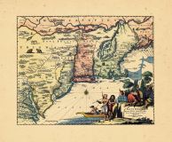
Map - Page 1 - BELGII NOVI,/AN... |
BELGII NOVI,/ANGLIAE NOVAE, ET... |
|
JANSSON, JAN / SCHEN... |
1694 |
OML |
|
 |
Map - Page 1 - BELGII NOVI,/AN... |
BELGII NOVI,/ANGLIAE NOVAE, ET... |
|
JANSSONIUS, JOANNES |
1651 |
OML |
|
 |
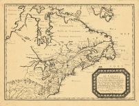
Map - Page 1 - CANADA/ou/NOVVE... |
CANADA/ou/NOVVELLE/FRANCE |
|
MALLET, ALAIN MANESS... |
1686 |
OML |
|
 |
Map - Page 1 - CARTA D'UNA PAR... |
CARTA D'UNA PARTE/DELL'AMERICA... |
|
BELLIN, JACQUES NICO... |
1755- |
OML |
|
 |
Map - Page 1 - Carta particola... |
Carta particolare della nuoua ... |
|
DUDLEY, ROBERT |
1661 |
OML |
|
 |
Map - Page 1 - CARTE REDUITE D... |
CARTE REDUITE DES/COSTES ORIEN... |
|
BELLIN, JACQUES NICO... |
1757 |
OML |
|
 |
Map - Page 1 - CARTE REDUITE/D... |
CARTE REDUITE/DES COTES ORIENT... |
|
DEPOT GENERAL DES CA... |
1780 |
OML |
|
 |
Map - Page 1 - CARTE/DE LA NOU... |
CARTE/DE LA NOUVELLE ANGLETERR... |
|
BELLIN, JACQUES NICO... |
1757 |
OML |
|
 |
Map - Page 1 - CARTE/de la NOU... |
CARTE/de la NOUVELLE/ANGLETERR... |
|
BERTHOLON, C. |
1799 |
OML |
|
 |
Map - Page 1 - CARTE/DE LA PAR... |
CARTE/DE LA PARTIE NORD,/DES E... |
|
BONNE, RIGOBERT |
1780 |
OML |
|
 |
Map - Page 1 - CARTE/de la/Nou... |
CARTE/de la/Nouvelle ANGLETERR... |
|
LAPORTE, JOSEPH de |
1781 |
OML |
|
 |
Map - Page 1 - CARTE/DU/THEATR... |
CARTE/DU/THEATRE DE LA GUERRE/... |
|
BRION DE LA TOUR, LO... |
1778 |
OML |
|
 |
Map - Page 1 - CHART/OF/GEORGE... |
CHART/OF/GEORGES SHOAL and BAN... |
|
WILKES, LIEUT. COMMA... |
1837 |
OML |
|
 |
Map - Page 1 - Commercial Surv... |
Commercial Survery of New Engl... |
|
Bureau of Foreign an... |
1949 |
OML |
|
 |
Map - Page 1 - Costes et Riuie... |
Costes et Riuieres/de VIRGINIE... |
|
MICHAULT, R. / JUSTE... |
1674 |
OML |
|
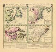 |
Map - Page 1 - DOMINIA ANGLORU... |
DOMINIA ANGLORUM/in/AMERICA SE... |
|
HOMANN HEIRS/MOLL, H... |
1737- |
OML |
|
 |
Map - Page 1 - LE CANADA,ou No... |
LE CANADA,ou Nouvelle France,a... |
|
SANSON, NICOLAS |
1656 |
OML |
|
 |
Map - Page 1 - Le Cours du/MIS... |
Le Cours du/MISSISIPI,/ou de S... |
|
FER, NICOLAS DE |
1718 |
OML |
|
 |
Map - Page 1 - MAP OF NEW ENGL... |
MAP OF NEW ENGLAND AND NEW YOR... |
|
SPEED, JOHN / LAMB, ... |
1676 |
OML |
|
 |
Map - Page 1 - MAP of the NORT... |
MAP of the NORTHERN,or,NEW ENG... |
|
RUSSELL, JOHN |
1795 |
OML |
|
 |
Map - Page 1 - Map of/MAINE, N... |
Map of/MAINE, NEW HAMPSHIRE,/V... |
|
BURR, DAVID H. |
1839 |
OML |
|
 |
Map - Page 1 - MAPA GEOGRAFICO... |
MAPA GEOGRAFICO/QUE COMPREHEND... |
|
LOPEZ, TOMAS |
1778 |
OML |
|
 |
Map - Page 1 - MAPPA/GEOGRAPHI... |
MAPPA/GEOGRAPHICA/AMERICAE/SEP... |
|
EULER, LEONHARD von |
1755 |
OML |
|
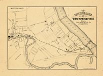 |
Map - Page 1 - MITTINEAGUE/and... |
MITTINEAGUE/and/WEST SPRINGFIE... |
|
PRICE and LEE CO., T... |
1895 |
OML |
|
 |
Map - Page 1 - NIEUW/ENGELAND/... |
NIEUW/ENGELAND/in Twee/Scheept... |
|
AA, PIETER VANDER |
1707 |
OML |
|
 |
Map - Page 1 - NORTH AMERICA/E... |
NORTH AMERICA/EAST COAST/BAY O... |
|
ADMIRALTY, HYDROGRAP... |
1857 |
OML |
|
 |
Map - Page 1 - NOUVELLE ANGLET... |
NOUVELLE ANGLETERRE/NLLE. YORK... |
|
VAUGONDY, ROBERT de,... |
1749 |
OML |
|
 |
Map - Page 1 - NOUVELLE CARTE ... |
NOUVELLE CARTE PARTICULIERE DE... |
|
POPPLE, HENRY / COVE... |
1741 |
OML |
|
 |
Map - Page 1 - NOUVELLE/HOLLAN... |
NOUVELLE/HOLLANDE,/(a present/... |
|
AA, PIETER VANDER |
1714- |
OML |
|
 |
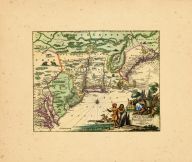
Map - Page 1 - NOVA BELGICA ET... |
NOVA BELGICA ET ANGLIA NOVA |
|
JANSSON, JAN |
1652-58 |
OML |
|
 |
Map - Page 1 - NOVA BELGICA ET... |
NOVA BELGICA ET ANGLIA NOVA |
|
JANSSON, JAN / VALK,... |
1710- |
OML |
|
 |
Map - Page 1 - NOVA TABULA GEO... |
NOVA TABULA GEOGRAPHICA COMPLE... |
|
VISSCHER, NICOLAS / ... |
1700- |
OML |
|
 |
Map - Page 1 - NOVA/BELGICA/ET... |
NOVA/BELGICA/ET/ANGLIA/NOVA |
|
BLAEU, WILLEM |
1638 |
OML |
|
 |
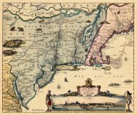
Map - Page 1 - NOVI BELGII NOV... |
NOVI BELGII NOVAEQUE ANGLIAE/P... |
|
VISSCHER, NICOLAS / ... |
1729- |
OML |
|
 |
Map - Page 1 - NOVI BELGII NOV... |
NOVI BELGII NOVAEQUE ANGLIAE/V... |
|
VISSCHER, NICOLAS |
1684 |
OML |
|
 |
Map - Page 1 - NOVI BELGII NOV... |
NOVI BELGII NOVAEQUE ANGLIAE/V... |
|
ALLARD, HUGO |
1662- |
OML |
|
 |
Map - Page 1 - NOVI BELGII NOV... |
NOVI BELGII NOVAEQUE ANGLIAE/V... |
|
VISSCHER, NICOLAS |
1656- |
OML |
|
 |
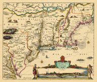
Map - Page 1 - NOVI BELGII,Quo... |
NOVI BELGII,Quod nunc NOVI JOR... |
|
OGILBY, JOHN |
1670 |
OML |
|
 |
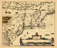
Map - Page 1 - NOVI BELGII,Quo... |
NOVI BELGII,Quod nunc NOVI JOR... |
|
OGILBY, JOHN |
1670 |
OML |
|
 |
Map - Page 1 - NOVI BELGII/NOV... |
NOVI BELGII/NOVAEQUE ANGLIAE N... |
|
DANCKERS, JUSTO |
1680- |
OML |
|
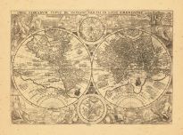 |
Map - Page 1 - ORBIS TERRARUM ... |
ORBIS TERRARUM TYPUS DE INTEGR... |
|
PLANCIUS, PETRUS |
1599 |
OML |
|
 |
Map - Page 1 - PART OF/NEW/ENG... |
PART OF/NEW/ENGLAND/Sold by I.... |
|
THORNTON, J. AND FIS... |
1689 |
OML |
|
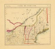 |
Map - Page 1 - PARTIE DES ETAT... |
PARTIE DES ETATS-UNIS. No.43. |
|
VANDERMAELEN, PHILIP... |
1827 |
OML |
|
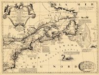 |
Map - Page 1 - PARTIE ORIENTAL... |
PARTIE ORIENTALE DU CANADA |
|
CORONELLI, V.M. / NO... |
1689 |
OML |
|
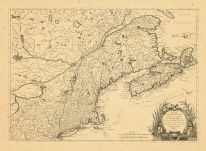 |
Map - Page 1 - PARTIE/SEPTENTR... |
PARTIE/SEPTENTRIONALE/Des Poss... |
|
MITCHELL, JOHN / ANO... |
1778 |
OML |
|
 |
Map - Page 1 - Pas-Kaart/Vande... |
Pas-Kaart/Vande zee Kusten ind... |
|
KEULEN, JOHANNES van |
1684 |
OML |
|
 |
Map - Page 1 - Pascaerte van/N... |
Pascaerte van/NIEV NEDERLANT,/... |
|
JACOBSZ, THEUNIS [LO... |
1681 |
OML |
|
 |
Map - Page 1 - Pascaerte van/T... |
Pascaerte van/TERRA NOVA NOVA ... |
|
ROGGEVEEN, ARENT |
1675 |
OML |
|
 |
Map - Page 1 - RECENS EDITA/to... |
RECENS EDITA/totius/NOVI BELGI... |
|
SEUTTER, MATTHAUS / ... |
1762+ |
OML |
|
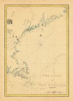 |
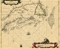
Map - Page 1 - THE COAST/of/NE... |
THE COAST/of/NEW ENGLAND |
|
DES BARRES, J.F.W |
1781 |
OML |
|
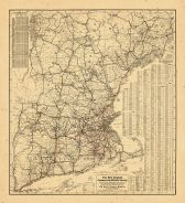 |
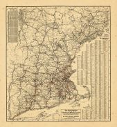
Map - Page 1 - The New England... |
The New England/Commercial and... |
|
BULLARD COMPANY, PUB... |
1910 |
OML |
|
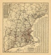 |
Map - Page 1 - The New England... |
The New England/Commercial and... |
|
HOME EDUCATOR COMPAN... |
1905 |
OML |
|
 |
Map - Page 1 - THE SEAT OF WAR... |
THE SEAT OF WAR/IN/NEW ENGLAND... |
|
SAYER, ROBERT AND BE... |
1775 |
OML |
|
 |
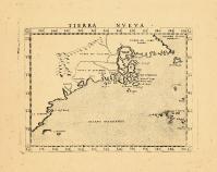
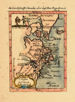
Map - Page 1 - TIERRA NVEVA |
TIERRA NVEVA |
|
RUSCELLI, GIROLAMO /... |
1598-99 |
OML |
|
 |
Map - Page 1 - TOTIUS NEOBELGI... |
TOTIUS NEOBELGII NOVA ET ACCUR... |
|
ALLARD, HUGO / OTTEN... |
1720- |
OML |
|
 |
Map - Page 1 - UNTITLED GLOBE ... |
UNTITLED GLOBE GORE |
|
CORONELLI, VICENZO M... |
1699- |
OML |
|
 |
Map - Page 1 - [COAST OF ME, N... |
[COAST OF ME, NH, MA- CAPE ELI... |
|
DES BARRES, J.F.W. |
1777-82 |
OML |
|
 |
Map - Page 2 - A MAP OF THE MO... |
A MAP OF THE MOST INHABITED PA... |
|
JEFFERYS, THOMAS / G... |
1755 |
OML |
|
 |
Map - Page 2 - A MAP OF THE/UN... |
A MAP OF THE/UNITED STATES/of/... |
|
ARROWSMITH, AARON |
1799 |
OML |
|
 |
Map - Page 2 - A MAP of/the mo... |
A MAP of/the most INHABITED pa... |
|
JEFFERYS, THOMAS / G... |
1774 |
OML |
|
 |
Map - Page 2 - A MAP of/the mo... |
A MAP of/the most INHABITED pa... |
|
JEFFERYS, THOMAS / G... |
1794 |
OML |
|
 |
Map - Page 2 - New Commercial,... |
New Commercial, Sportsmen's an... |
|
BULLARD COMPANY, THE |
1909 |
OML |
|
 |
Map - Page 2 - The New England... |
The New England/Commercial and... |
|
BULLARD COMPANY, THE |
1909 |
OML |
|
 |
Map - Page 2 - UNITED STATES o... |
UNITED STATES of Nth. AMERICA/... |
|
TARDIEU, P.F. [AFTER... |
1812 |
OML |
|

 Cart
Cart