Tennessee Historical Maps and Atlases
The state of Tennessee collection contains 117 atlases spanning 210 years of growth and development (1793 through 2003).
Within the atlases are 23,360 historical maps, illustrations, and histories many of which contain family names ideal for genealogical research. Others are rare antique maps, part of the collection by an exclusive arrangement with the Osher Map Library. The state of Tennessee has 20 of these antiquarian maps dating back as early as 1793.
|
Displaying 1- 50 of 116 in total
|
Next >> |
Click on a column header to sort table.
|
Name |
Attributes |
Quality |
Publisher |
State |
Date |
|
Name |
Atlas |
Attributes |
Publisher |
Date |
Collection |
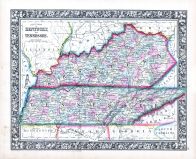 |
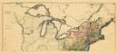
Kentucky and Tennessee |
World Atlas 1864 Mitchells New... |
 |
S. Augustus Mitchell |
1864 |
HMW |
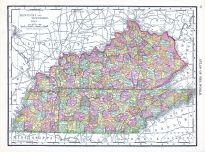 |
Kentucky and Tennessee |
World Atlas 1913 |
|
Rand McNally and Com... |
1913 |
HMW |
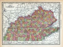 |
Page 078 - Kentucky and Tennes... |
World Atlas 1911c from Minneso... |
|
Rand, McNally and Co... |
1911 |
HMW |
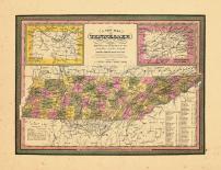 |
Map - Page 1 |
A New map of Tennessee with it... |
|
S. Augustust Mitchel... |
1846 |
OML |
|
 |
Map - Page 1 - A MAP OF THE/UN... |
A MAP OF THE/UNITED STATES/of/... |
|
ARROWSMITH, AARON |
1799 |
OML |
|
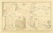 |
Map - Page 2 - ATLAS/TO ACCOMP... |
ATLAS/TO ACCOMPANY THE OFFICIA... |
|
DAVIS, MAJOR GEORGE ... |
1891 |
OML |
|
 |
Map - Page 2 - ATLAS/TO ACCOMP... |
ATLAS/TO ACCOMPANY THE OFFICIA... |
|
DAVIS, MAJOR GEORGE ... |
1891 |
OML |
|
 |
Map - Page 2 - ATLAS/TO ACCOMP... |
ATLAS/TO ACCOMPANY THE OFFICIA... |
|
DAVIS, MAJOR GEORGE ... |
1891 |
OML |
|
 |
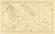
Map - Page 3 - ATLAS/TO ACCOMP... |
ATLAS/TO ACCOMPANY THE OFFICIA... |
|
DAVIS, MAJOR GEORGE ... |
1891 |
OML |
|
 |
Map - Page 3 - ATLAS/TO ACCOMP... |
ATLAS/TO ACCOMPANY THE OFFICIA... |
|
DAVIS, MAJOR GEORGE ... |
1891 |
OML |
|
 |
Map - Page 3 - ATLAS/TO ACCOMP... |
ATLAS/TO ACCOMPANY THE OFFICIA... |
|
DAVIS, MAJOR GEORGE ... |
1891 |
OML |
|
 |
Map - Page 3 - UNITED STATES o... |
UNITED STATES of Nth. AMERICA/... |
|
TARDIEU, P.F. [AFTER... |
1812 |
OML |
|
 |
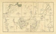
Map - Page 4 - ATLAS/TO ACCOMP... |
ATLAS/TO ACCOMPANY THE OFFICIA... |
|
DAVIS, MAJOR GEORGE ... |
1891 |
OML |
|
 |
Map - Page 5 - ATLAS/TO ACCOMP... |
ATLAS/TO ACCOMPANY THE OFFICIA... |
|
DAVIS, MAJOR GEORGE ... |
1891 |
OML |
|
 |
Map - Page 5 - ATLAS/TO ACCOMP... |
ATLAS/TO ACCOMPANY THE OFFICIA... |
|
DAVIS, MAJOR GEORGE ... |
1891 |
OML |
|
 |
Map - Page 6 - ATLAS/TO ACCOMP... |
ATLAS/TO ACCOMPANY THE OFFICIA... |
|
DAVIS, MAJOR GEORGE ... |
1891 |
OML |
|
 |
Map - Page 6 - ATLAS/TO ACCOMP... |
ATLAS/TO ACCOMPANY THE OFFICIA... |
|
DAVIS, MAJOR GEORGE ... |
1891 |
OML |
|
 |
Map - Page 6 - ATLAS/TO ACCOMP... |
ATLAS/TO ACCOMPANY THE OFFICIA... |
|
DAVIS, MAJOR GEORGE ... |
1891 |
OML |
|
 |
Map - Page 6 - ATLAS/TO ACCOMP... |
ATLAS/TO ACCOMPANY THE OFFICIA... |
|
DAVIS, MAJOR GEORGE ... |
1891 |
OML |
|
 |
Map - Page 6 - ATLAS/TO ACCOMP... |
ATLAS/TO ACCOMPANY THE OFFICIA... |
|
DAVIS, MAJOR GEORGE ... |
1891 |
OML |
|
|
Displaying 1- 50 of 116 in total
|
Next >> |

 Cart
Cart