
 Cart
Cart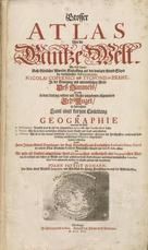
Grosser Atlas
Homann, Johann Baptist, 1716
Image Quality:
 High
High
This massive, 4" thick work from 1716 is referred to as the Hommann's Grosser Atlas or even The Grand Atlas of the World. Between the covers are highly detailed maps of most known regions of the globe with a considerable number describing the regions and kingdoms of Homman's German homeland. It is worthwhile to pay attention to each map's cartouche, as more often than not, the featured characters are illustrated in the traditional 16th century dress of the country shown on the map. Also of note are the numerous celestial charts describing the motion of heavenly bodies and a very detailed early map of the moon. Accompanying the maps are many illustrations of 16th century mechanical navigational devices, globe design, warfare engineering, and European shipbuilding plans.
Maps Blank Calibration Cover, Back inside Cover, Back outside Cover, Front inside Cover, Front outside Frontispeice Illustration Illustration & Text OML Barcode Other Spine Text Title Page
 Indicates a map that is georeferenced


![ARENA MARTIS IN BELGIO, QUA PROVINCIAE X CATHOLICAE INFERIORIS GERMANIAE cum vicinis EPISCOPATIBUS, COLONIENSI ET LEODIENSI [with panorama of seige of Liège] 0343-00, Grosser Atlas](/Images/Maps/OL/Bound/1822/web-1822-0343-00,final/TileGroup0/0-0-0.jpg "ARENA MARTIS IN BELGIO, QUA PROVINCIAE X CATHOLICAE INFERIORIS GERMANIAE cum vicinis EPISCOPATIBUS, COLONIENSI ET LEODIENSI [with panorama of seige of Liège] 0343-00, Grosser Atlas")


![CIRCULUS SAXONIAE INFERIORIS [with Hamburg inset] 0262-00, Grosser Atlas](/Images/Maps/OL/Bound/1822/web-1822-0262-00,final/TileGroup0/0-0-0.jpg "CIRCULUS SAXONIAE INFERIORIS [with Hamburg inset] 0262-00, Grosser Atlas")
![CIRCULUS SAXONIAE SUPERIORIS [Centered on Leipzig] 0250-00, Grosser Atlas](/Images/Maps/OL/Bound/1822/web-1822-0250-00,final/TileGroup0/0-0-0.jpg "CIRCULUS SAXONIAE SUPERIORIS [Centered on Leipzig] 0250-00, Grosser Atlas")


![DUCATUS WURTENBERGICI cum Locis limitaneis, utpote maxima parte CIRCULI SUEVICI [Plates 1 and 2 of this 4 plate map] 0241-00, Grosser Atlas](/Images/Maps/OL/Bound/1822/web-1822-0241-00,final/TileGroup0/0-0-0.jpg "DUCATUS WURTENBERGICI cum Locis limitaneis, utpote maxima parte CIRCULI SUEVICI [Plates 1 and 2 of this 4 plate map] 0241-00, Grosser Atlas")
![DUCATUS WURTENBERGICI cum Locis limitaneis, utpote maxima parte CIRCULI SUEVICI [Plates 3 and 4 of this 4 plate map] 0244-00, Grosser Atlas](/Images/Maps/OL/Bound/1822/web-1822-0244-00,final/TileGroup0/0-0-0.jpg "DUCATUS WURTENBERGICI cum Locis limitaneis, utpote maxima parte CIRCULI SUEVICI [Plates 3 and 4 of this 4 plate map] 0244-00, Grosser Atlas")


![LANDGRAVIA[TUS] THURINGIAE[Centered on Erfurd] 0253-00, Grosser Atlas](/Images/Maps/OL/Bound/1822/web-1822-0253-00,final/TileGroup0/0-0-0.jpg "LANDGRAVIA[TUS] THURINGIAE[Centered on Erfurd] 0253-00, Grosser Atlas")


![Nova et accurata TERRITORII VLMENSIS cum DOMINIO WAINENSI [Centered on Ulm with territories of Vienna in Inset] 0247-00, Grosser Atlas](/Images/Maps/OL/Bound/1822/web-1822-0247-00,final/TileGroup0/0-0-0.jpg "Nova et accurata TERRITORII VLMENSIS cum DOMINIO WAINENSI [Centered on Ulm with territories of Vienna in Inset] 0247-00, Grosser Atlas")

![NOVA TERRITOR[II] ERFORDIEN 0259-00, Grosser Atlas](/Images/Maps/OL/Bound/1822/web-1822-0259-00,final/TileGroup0/0-0-0.jpg "NOVA TERRITOR[II] ERFORDIEN 0259-00, Grosser Atlas")


![PORTUGALLIAE ET ALGARABIA | REGNUM BRASILIAE in America Australi Primogeniti Portug Principis Dos Amplissima [Brazil] 0118-00, Grosser Atlas](/Images/Maps/OL/Bound/1822/web-1822-0118-00,final/TileGroup0/0-0-0.jpg "PORTUGALLIAE ET ALGARABIA | REGNUM BRASILIAE in America Australi Primogeniti Portug Principis Dos Amplissima [Brazil] 0118-00, Grosser Atlas")
![POSTARUM SEU VEREDARIORUM STATIONES PER GERMANIAM ET PROVINCIAS ADIACENTES [Postal Map] 0184-00, Grosser Atlas](/Images/Maps/OL/Bound/1822/web-1822-0184-00,final/TileGroup0/0-0-0.jpg "POSTARUM SEU VEREDARIORUM STATIONES PER GERMANIAM ET PROVINCIAS ADIACENTES [Postal Map] 0184-00, Grosser Atlas")


![PRINCIPATUS ISENACENSIS [Showing Gotha and Erfurt] 0256-00, Grosser Atlas](/Images/Maps/OL/Bound/1822/web-1822-0256-00,final/TileGroup0/0-0-0.jpg "PRINCIPATUS ISENACENSIS [Showing Gotha and Erfurt] 0256-00, Grosser Atlas")

![PROSPECT und GRUND-RISS der KAYSERL. RESIDENZ-STADT WIEN [Vienna] 0196-00, Grosser Atlas](/Images/Maps/OL/Bound/1822/web-1822-0196-00,final/TileGroup0/0-0-0.jpg "PROSPECT und GRUND-RISS der KAYSERL. RESIDENZ-STADT WIEN [Vienna] 0196-00, Grosser Atlas")
![PROSPECT und GRUNDRIS der des HEIL : ROM. REICHS STADT NURNBERG famt ihren LINIEN und GEGEND [Nuremberg] 0235-00, Grosser Atlas](/Images/Maps/OL/Bound/1822/web-1822-0235-00,final/TileGroup0/0-0-0.jpg "PROSPECT und GRUNDRIS der des HEIL : ROM. REICHS STADT NURNBERG famt ihren LINIEN und GEGEND [Nuremberg] 0235-00, Grosser Atlas")


![TOTIUS AMERICAE SEPTENTRIONALIS ET MERIDIONALIS NOVISSIMA REPREAESENTATIO quam ex singulis recentium Geographorum Tabulis collecta luci publicae accommodavit [California as an Island] 0100-00, Grosser Atlas](/Images/Maps/OL/Bound/1822/web-1822-0100-00,final/TileGroup0/0-0-0.jpg "TOTIUS AMERICAE SEPTENTRIONALIS ET MERIDIONALIS NOVISSIMA REPREAESENTATIO quam ex singulis recentium Geographorum Tabulis collecta luci publicae accommodavit [California as an Island] 0100-00, Grosser Atlas")


These antique maps and atlases are part of the Historic Map Works, Residential Genealogy™ historical map collection, the largest digital collection of rare, ancient, old, historical, cadastral and antiquarian maps of its type. Read about the collection. Browse entire collection.
Research Prints
All research prints will be printed with a light watermark.
Research Prints are color prints fitted to 11" x 17" paper ideal for research and educational use, but not suitable for framing as center seams and imperfections will not be removed. Orders for less than 15 research prints will be mailed folded in an envelope. Larger orders will be shipped flat via UPS.
All research prints will be printed with a light watermark.
Click here to see an example of a research print.
Research Prints are color prints fitted to 11" x 17" paper ideal for research and educational use, but not suitable for framing as center seams and imperfections will not be removed. Orders for less than 15 research prints will be mailed folded in an envelope. Larger orders will be shipped flat via UPS.